Current Affairs 12th Class

  Population   The people are very important component of a country. India is the second most populous country after China in the world with its total population of 1,028 million (2001). India’s population is larger than the total population of North America, South America and Australia put together. More often, it is argued that such a large population invariably puts pressure on its limited resources and is also responsible for many socio-economic problems in the country.   How do you perceive the idea of India? Is it simply a territory? Does this signify an amalgam of people? Is it a territory inhabited by people living under certain institutions of governance?   In this chapter, we will discuss the patterns of distribution, density, growth and composition of India’s population.   Sources of Population Data Population data are collected through Census operation held every 10 years in our country. The first population Census in India was conducted in 1872 but its first complete Census was conducted only in 1881.   Distribution of Population Examine Fig. 1.1 and try to describe the patterns of spatial distribution of population shown on it. It is clear that India has a highly uneven pattern of population distribution. The percentage shares of population of the states and Union Territories in the country (Appendix–i) show that Uttar Pradesh has the highest population followed by Maharashtra, Bihar, West Bengal and Andhra Pradesh.   Activity Looking at the data in Appendix (i) arrange the Indian states and union territories according to their sizes and population and find out:   Fig. 1.1: India - Distribution of Population   States/UTs of large size and large population States/UTs of large size but small population States/UTs of smaller size but larger population   Check from the table (Appendix–i) that U.P., Maharashtra, Bihar, West Bengal, Andhra Pradesh along with Tamil Nadu, Madhya Pradesh, Rajasthan, Karnataka and Gujarat, together account for about 76 per cent of the total population of the country. On the other hand, share of population is very small in the states like Jammu & Kashmir (0.98%), Arunachal Pradesh (0.11%) and Uttaranchal (0.83%) in spite of these states having fairly large geographical area.   Such an uneven spatial distribution of population in India suggests a close relationship between population and physical, socioeconomic and historical factors. As far as the physical factors are concerned, it is clear that climate along with terrain and availability of water largely determines the pattern of the population distribution. Consequently, we observe that the North Indian Plains, deltas and Coastal Plains have higher proportion of population than the interior districts of southern and central Indian States, Himalayas, some of the north eastern and the western states. However, development of irrigation (Rajasthan), availability of mineral and energy resources (Jharkhand) and development of transport network (Peninsular States) have resulted in moderate to high proportion of population in areas which were previously very thinly populated (Fig. 1.1).   Among more...

  Migration   Ram Babu, working as an engineer in Bhilai Steel Plant, Chhattisgarh, was born in a small village of district Bhojpur, Bihar. At an early age of twelve he moved to a nearby town Ara to complete his intermediate level studies. He went to Sindri, Jharkhand for his engineering degree and he got a job at Bhilai, where he is living for the last 31 years. His parents were illiterate and the only source of their livelihood was meagre income from agriculture. They spent their whole life in that village.   Ram Babu has three children who got their education up to the intermediate level at Bhilai and then moved to different places for higher education. First one studied at Allahabad and Mumbai and is presently working in Delhi as a scientist. The second child got her higher education from different universities in India and is now working in USA. The third one after finishing her education settled at Surat after marriage.   This is not a story of only Ram Babu and his children but such movements are increasingly becoming universal trend. People have been moving from one village to another, from villages to towns, from smaller towns to bigger towns and from one country to another.   In your Book Fundamentals of Human Geography you have already learnt about the concept and definition of migration. Migration has been an integral part and a very important factor in redistributing population over time and space. India has witnessed the waves of migrants coming to the country from Central and West Asia and also from Southeast Asia. In fact, the history of India is a history of waves of migrants coming and settling one after another in different parts of the country. In the words of a renowned poet Firaque Gorakhpuri;   SAR ZAMIN-E-HIND PAR AQWAM-E-ALAM KE FIRAQUE CARVAN BASTE GAYE, HINDOSTAN BANTA GAYA   (The carvans of people from all parts of the world kept on coming and settling in India and led to the formation of India.)   Similarly, large numbers of people from India too have been migrating to places in search of better opportunities specially to the countries of the Middle-East, Western Europe, America, Australia and East and South East Asia.   Indian Diaspora During colonial period (British period) millions of the indentured labourers were sent to Mauritius, Caribbean islands (Trinidad, Tobago and Guyana), Fiji and South Africa by British from Uttar Pradesh and Bihar; to Reunion Island, Guadeloupe, Martinique and Surinam by French and Dutch and by Portuguese from Goa, Daman and Diu to Angola, Mozambique to work as plantation workers. All such migrations were covered under the time-bound contract known as Girmit Act (Indian Emigration Act). However, the living conditions of these indentured labourers were not better than the slaves.   The second wave of migrants ventured out into the neighbouring countries in recent times as professionals, artisans, traders and factory workers, in search of economic opportunities more...

  Human Development   Sixty years ago, Rekha was born in a family of small farmer in Uttaranchal. She helped her mother in household chores. While her brothers went to school, she did not receive any education. She was dependent on her in laws after she was widowed immediately after marriage. She could not be economically independent and faced neglect. Her brother helped her to migrate to Delhi.   For the first time, she travelled by bus and train and was exposed to a large city like Delhi. After a while, the same city which attracted her with its buildings, roads, avenues and facilities and amenities disillusioned her.   With greater familiarity of the city, she could comprehend the paradoxes. The jhuggi and slum clusters, traffic jams, congestion, crimes, poverty, small children begging on traffic lights, people sleeping on footpaths, polluted water and air revealed another face of development. She used to think whether development and under-development coexist? Whether development help some segments of population more than the other? Does development create haves and have nots? Let us examine these paradoxes and try to understand the phenomena.   Of all the paradoxes of our times mentioned in the story, development is the most significant one. Development of a few regions, individuals brought about in a short span of time leads to poverty and malnutrition for many along with large scale ecological degradation. Is development class biased?   Apparently, it is believed that “Development is freedom” which is often associated with modernisation, leisure, comfort and affluence. In the present context, computerisation, industrialisation, efficient transport and communication network, large education system, advanced and modern medical facilities, safety and security of individuals, etc. are considered as the symbols of development. Every individual, community and government measures its performance or levels of development in relation to the availability and access to some of these things. But, this may be partial and one-sided view of development. It is often called the western or euro-centric view of development. For a development, make amendments and changes its indicators but also ranks all the countries postcolonial country like India, colonisation, marginalisation, social discrimination and regional disparity, etc. show the other face of development.   Thus, for India, development is a mixed bag of opportunities as well as neglect and deprivations. There are a few areas like the metropolitan centres and other developed enclaves that have all the modern facilities available to a small section of its population. At the other extreme of it, there are large rural areas and the slums in the urban areas that do not have basic amenities like potable water, education and health infrastructure available to majority of this population. The situation is more alarming if one looks at the distribution of the development opportunities among different sections of our society. It is a well-established fact that majority of the scheduled castes, scheduled tribes, landless agricultural labourers, poor farmers and slums dwellers, etc. are the most marginalised lot. more...

  Human Settlements   Human Settlement means cluster of dwellings of any type or size where human beings live. For this purpose, people may erect houses and other structures and command some area or territory as their economic support-base. Thus, the process of settlement inherently involves grouping of people and apportioning of territory as their resource base.   Settlements vary in size and type. They range from a hamlet to metropolitan cities. With size, the economic character and social structure of settlements changes and so do its ecology and technology. Settlements could be small and sparsely spaced; they may also be large and closely spaced. The sparsely located small settlements are called villages, specialising in agriculture or other primary activities. On the other hand, there are fewer but larger settlements which are termed as urban settlements specialising in secondary and tertiary activities. The basic differences between rural and urban settlements are as follows:  
  • The rural settlements derive their life support or basic economic needs from land based primary economic activities, whereas, urban settlements, depend on processing of raw materials and manufacturing of finished goods on the one hand and a variety of services on the other.
  • Cities act as nodes of economic growth, provide goods and services not only to urban dwellers but also to the people of the rural settlements in their hinterlands in return for food and raw materials. This functional relationship between the urban and rural settlements takes place through transport and communication network.
  • Rural and urban settlements differ in terms of social relationship, attitude and outlook. Rural people are less mobile and therefore, social relations among them are intimate. In urban areas, on the other hand, way of life is complex and fast, and social relations are formal.
  Types of Rural Settlement Types of the settlement are determined by the extent of the built-up area and inter-house distance. In India compact or clustered village of a few hundred houses is a rather universal feature, particularly in the northern plains. However, there are several areas, which have other forms of rural settlements. There are various factors and conditions responsible for having different types of rural settlements in India. These include: (i) physical features - nature of terrain, altitude, climate and availability of water (ii) cultural and ethenic factors - social structure, caste and religion (iii) security factors - defence against thefts and robberies. Rural settlements in India can broadly be put into four types:
  • Clustered, agglomerated or nucleated,
  • Semi-clustered or fragmented,
  • Hamleted, and
  • Dispersed or isolated.
  Clustered Settlements The clustered rural settlement is a compact or closely built up area of houses. In this type of village the general living area is distinct and separated from the surrounding farms, barns and pastures. The closely built-up area and its intervening streets present some recognizable pattern or geometric shape, such as rectangular, radial, linear, etc. Such settlements are generally found in fertile more...

  Land Resources and Agriculture   You must have observed that the land around you is put to different uses. Some land is occupied by rivers, some may have trees and on some parts roads and buildings have been built. Different types of lands are suited to different uses. Human beings thus, use land as a resource for production as well as residence and recreation. Thus, the building of your school, roads on which you travel, parks in which you play, fields in which crops are grown and the pastures where animals graze represent different uses to which land is put.   Land Use Categories Land-use records are maintained by land revenue department. The land use categories add up to reporting area, which is somewhat different from the geographical area. The Survey of India is responsible for measuring geographical area of administrative units in India. Have you ever used a map prepared by Survey of India? The difference between the two concepts are that while the former changes somewhat depending on the estimates of the land revenue records, the latter does not change and stays fixed as per Survey of India measurements. You may be familiar with land use categories as they are also included in your Social Science textbook of Class X.   The land-use categories as maintained in the Land Revenue Records are as follows:   (i) Forests: It is important to note that area under actual forest cover is different from area classified as forest. The latter is the area which the Government has identified and demarcated for forest growth. The land revenue records are consistent with the latter definition. Thus, there may be an increase in this category without any increase in the actual forest cover. (ii) Land put to Non-agricultural Uses: Land under settlements (rural and urban), infrastructure (roads, canals, etc.), industries, shops, etc. are included in this category. An expansion in the secondary and tertiary activities would lead to an increase in this category of land-use. (iii) Barren and Wastelands: The land which may be classified as a wasteland such as barren hilly terrains, desert lands, ravines, etc. normally cannot be brought under cultivation with the available technology. (iv) Area under Permanent Pastures and Grazing Lands: Most of this type land is owned by the village ‘Panchayat’ or the Government. Only a small proportion of this land is privately owned. The land owned by the village panchayat comes under ‘Common Property Resources’. (v) Area under Miscellaneous Tree Crops and Groves (Not included is Net sown Area): The land under orchards and fruit trees are included in this category. Much of this land is privately owned. (vi) Culturable Waste-Land: Any land which is left fallow (uncultivated) for more than five years is included in this category. It can be brought under cultivation after improving it through reclamation practices. (vii) Current Fallow: This is the land which is left without cultivation for one or less than one agricultural year. Fallowing more...

  Water Resources   Do you think that what exists today will continue to be so, or the future is going to be different in some respects? It can be said with some certainty that the societies will witness demographic transition, geographical shift of population, technological advancement, degradation of environment and water scarcity. Water scarcity is possibly to pose the greatest challenge on account of its increased demand coupled with shrinking supplies due to over utilisation and pollution. Water is a cyclic resource with abundant supplies on the globe. Approximately, 71 per cent of the earth’s surface is covered with it but fresh water constitutes only about 3 per cent of the total water. In fact, a very small proportion of fresh water is effectively available for human use. The availability of fresh water varies over space and time. The tensions and disputes on sharing and control of this scare resource are becoming contested issues among communities, regions, and states. The assessment, efficient use and conservation of water, therefore, become necessary to ensure development. In this chapter, we shall discuss water resources in India, its geographical distribution, sectoral utilisation, and methods of its conservation and management.   Water Resources of India India accounts for about 2.45 per cent of world’s surface area, 4 per cent of the world’s water resources and about 16 per cent of world’s population. The total water available from precipitation in the country in a year is about 4,000 cubic km. The availability from surface water and replenishable groundwater is 1,869 cubic km. Out of this only 60 per cent can be put to beneficial uses. Thus, the total utilizable water resource in the country is only 1,122 cubic km.   Surface Water Resources There are four major sources of surface water. These are rivers, lakes, ponds, and tanks. In the country, there are about 10,360 rivers and their tributaries longer than 1.6 km each. The mean annual flow in all the river basins in India is estimated to be 1,869 cubic km. However, due to topographical, hydrological and other constraints, only about 690 cubic km (32 per cent) of the available surface water can be utilised. Water flow in a river depends on size of its catchment area or river basin and rainfall within its catchment area. You have studied in your Class XI textbook Indias: Physical Environment” that precipitation in India has very high spatial variation, and it is mainly concentrated in Monsoon season. You also have studied in the textbook that some of the rivers in the country like the Ganga, the Brahmaputra, and the Indus have huge catchment areas. Given that precipitation is relatively high in the catchment areas of the Ganga, the Brahmaputra and the Barak rivers, these rivers, although account for only about one-third of the total area in the country, have 60 per cent of the total surface water resources. Much of the annual water flow in south Indian rivers like the Godavari, more...

  Mineral and Energy Resources   India is endowed with a rich variety of mineral resources due to its varied geological structure. Bulk of the valuable minerals are products of pre-palaezoic age (Refer: Chapter 2 of Class XI, Textbook: “Fundamentals of Physical Geography” and are mainly associated with metamorphic and igneous rocks of the peninsular India. The vast alluvial plain tract of north India is devoid of minerals of economic use. The mineral resources provide the country with the necessary base for industrial development. In this chapter, we shall discuss the availability of various types of mineral and energy resources in the country.   A mineral is a natural substance of organic or inorganic origin with definite chemical and physical properties.   Types of Mineral Resources On the basis of chemical and physical properties, minerals may be grouped under two main categories of metallics and non-metallics which may further be classified as follows:   
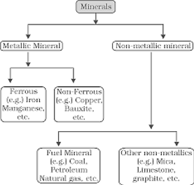
Fig. 7.1: Classification of Minerals             As, it is clear from the Fig. 7.1 metallic minerals are the sources of metals. Iron ore, copper, gold produce metal and are included in this category. Metallic minerals are further divided into ferrous and non-ferrous metallic minerals. Ferrous, as you know, refers to iron. All those minerals which have iron content are ferrous such as iron ore itself and those which do not have iron content are non-ferrous such as copper, bauxite, etc.   Non-metallic minerals are either organic in origin such as fossil fuels also known as mineral fuels which are derived from the buried animal and plant life such as coal and petroleum. Other type of non-metallic minerals are inorganic in origin such as mica, limestone and graphite, etc.   Minerals have certain characteristics. These are unevenly distributed over space. There is inverse relationship in quality and quantity of minerals i.e. good quality minerals are less in quantity as compared to low quality minerals. The third main characteristic is that all minerals are exhaustible over time. These take long to develop geologically and they cannot be replenished immediately at the time of need. Thus, they have to be conserved and not misused as they do not have the second crop.   Agencies involved in the Exploration of Minerals In India, systematic surveying, prospecting and exploration for minerals is undertaken by the Geological Survey of India (GSI), Oil and Natural Gas Commission (ONGC), Mineral Exploration Corporation Ltd. (MECL), National Mineral Development Corporation (NMDC), Indian Bureau of Mines (IBM), Bharat Gold Mines Ltd. (BGML), Hindustan Copper Ltd. (HCL), National Aluminium Company Ltd. (NALCO) and the Departments of Mining and Geology in various states.   Distribution of Minerals in India Most of the metallic minerals in India occur in the peninsular plateau region in the old crystalline rocks. Over 97 percent of coal reserves occur in the valleys of Damodar, Sone, Mahanadi and Godavari. Petroleum reserves are located in the sedimentary basins of Assam, more...

  Manufacturing Industries   We use various items to satisfy our needs. Agricultural products like wheat, rice, etc. are to be processed into flour, husked rice before we consume these. But besides bread and rice, we also require clothes, books, fans, cars, medicines, etc. and these are manufactured in various industries. In modern times industries have become very important part of an economy. They provide employment to large labour force and contribute significantly in the total national wealth/income.   Types of Industries Industries are classified in a number of ways. On the basis of size, capital investment and labour force employed, industries are classified as large, medium, small scale, and cottage industries. On the basis of ownership, industries are categorised as:   (i) public sector, (ii) private sector, and (iii) joint and cooperative sector, Public sector enterprises are government/state controlled companies or corporations funded by governments. Industries of strategic and national importance are usually in the public sector. Industries are also classified on the basis of the use of their products such as: (i) basic goods industries, (ii) capital goods industries (iii) intermediate goods industries, and (iv) consumer goods industries.   Another method of classifying industries is on the basis of raw materials used by them. Accordingly, these can be: (i) agriculture based industries, (ii) forest-based industries, (iii) mineral-based industries, and (iv) industrially processed raw material based industries.   Another common classification of industries is based on the nature of the manufactured products. Eight classes of industries, thus identified are: (1) Metallurgical Industries, (2) Mechanical Engineering Industries, (3) Chemical and Allied Industries, (4) Textile Industries, (5) Food Processing Industries, (6) Electricity Generation, (7) Electronics and (8) Communication Industries.  Sometimes, you also read about foot loose industries. What are these? Have they any relationship with raw material location or not?   Location of Industries Can you guess the reasons for the location of iron and steel industry in eastern and southern India? Why is there no iron and steel industry in U.P., Haryana, Punjab, Rajasthan and Gujarat?   Location of industries is influenced by several factors like access to raw materials, power, market, capital, transport and labour, etc. Relative significance of these factors varies with time and place. There is strong relationship between raw material and type of industry. It is economical to locate the manufacturing industries at a place where cost of production and delivery cost of manufactured goods to consumers are the least. Transport costs, to a great extent, depend on the nature of raw materials and manufactured products. A brief description of factors influencing the location of industries are given below:   Raw Materials Industries using weight-losing raw materials are located in the regions where raw materials are located. Why are the sugar mills in India located in sugarcane growing areas? Similarly, the locations of pulp industry, copper smelting and pig iron industries are located near their raw materials. In iron and steel industries, iron ore and coal both are weight-losing raw more...

  Planning and Sustainable Development in Indian Context   The word ‘planning’ is not new to you as it is a part of everyday usage. You must have used it with reference to preparation for your examination or visit to a hill station. It involves the process of thinking, formulation of a scheme or programme and implementation of a set of actions to achieve some goal. Though it is a very broad term, in this chapter, it has been used with reference to the process of economic development. It is, thus different from the traditional hit-and-miss methods by which   Overview of Planning Perspective in India India has centralised planning and the task of planning in India has been entrusted to the Planning Commission. It is a statutory body headed by the Prime Minister and has a Deputy Chairman and members. The planning in the country is largely carried out through Five Year Plans.   The First Five Year Plan was launched in 1951 and covered the period, 1951-52 to 1955-56. Second and Third Five Year Plans covered the period from 1956-57 to 1960-61 and 1961-62 to 1965-66 respectively. Two successive droughts during mid-sixties (1965-66 and 1966-67) and war with Pakistan in 1965 forced plan holiday in 1966-67 and 1968-69. This period was covered by annual plans, which are also termed as rolling plans. The Fourth Five Year Plan began in 1969-70 and ended in 1973-74. Following this the Fifth Five Year Plan began in 1974-75 but it was terminated by the then government one year earlier i.e. in 1977-78. The Sixth Five Year Plan took off in 1980. The Seventh Five Year Plan covered the period between 1985 and 1990. Once again due to the political instability and initiation of liberalisation policy, the Eighth Five Year Plan got delayed. It covered the period, 1992 to 1997. The Ninth Five Year Plan covered the period from 1997 to 2002. The Tenth Plan began in 2002 and it is still in progress. It will come to an end on 31.3.2007. The approach paper of the Eleventh Plan entitled. “Towards Faster and More Inclusive Growth” has already been approved.   reforms and reconstruction are often undertaken. Generally, there are two approaches to planning, i.e. sectoral planning and regional planning. The sectoral planning means formulation and implementation of the sets of schemes or programmes aimed at development of various sectors of the economy such as agriculture, irrigation, manufacturing, power, construction, transport, communication, social infrastructure and services.   There is no uniform economic development over space in any country. Some areas are more developed and some lag behind. This uneven pattern of development over space necessitates that the planners have a spatial perspective and draw the plans to reduce regional imbalance in development. This type of planning is termed as regional planning.   Target Area Planning The planning process has to take special care of those areas which have remained economically backward. As you know, the economic development more...

  Transport and Communication   We use many items in our daily life. From tooth paste to our bed tea, milk, clothes, soaps, food items, etc. are required every day. All these can be purchased from the market. Have you ever thought as to how these items are brought from the site of production? All the production is meant for consumption. From the fields and factory, the produce is brought to the place from where consumers purchase it. It is the transportation of these items from the site of their production to the market which make them available to the consumer.   We not only use material things like fruits, vegetables, books, clothes, etc. but also use ideas, views and messages in our daily life. Do you know we exchange our views, ideas and messages from one place to another or one individual to another while communicating with the help of various means?   The use of transport and communication depends upon our need to move things from place of their availability to the place of their use. Human-beings use various methods to move goods, commodities, ideas from one place to another.   The following diagram shows the major means of transportation.                Land Transport The pathways and unmetalled roads have been used for transportation in India since ancient times. With the economic and technological development, metalled roads and railways were developed to move large volume of goods and people from one place to another. Ropeways, cableways and pipelines were devised to cater to the demands of transporting specific goods under special circumstances.   Road Transport India has one of the largest road networks in the world with a total length of 33.1 lakh km (2005). About 85 per cent of passenger and 70 per cent of freight traffic are carried by roads every year. Road transport is relatively suitable for shorter distance travel.   Do You Know? Sher Shah Suri built the Shahi (Royal) road to strengthen and consolidate his empire from the Indus Valley to the Sonar Valley in Bengal. This road was renamed the Grand Trunk (GT) road during the British period, connecting Calcutta and Peshawar. At present, it extends from Amritsar to Kolkata. It is bifurcated into 2 segments: (a) National Highway (NH)-1 from Delhi to Amritsar, and (b) NH- 2 from Delhi to Kolkata.   Road transport in modern sense was very limited in India before World War-II. The first serious attempt was made in 1943 when ‘Nagpur Plan’ was drawn. This plan could not be implemented due to lack of coordination among the princely states and British India. After Independence, twenty-year road plan (1961) was introduced to improve the conditions of roads in India. However, roads continue to concentrate in and around urban centres. Rural and remote areas had the least connectivity by road.   For the purpose of construction and maintenance, roads are classified as National Highways (NH), more...


You need to login to perform this action.
You will be redirected in 3 sec spinner