Category : 6th Class
Maps
Summary
1. Maps are a representation of the whole or part of the earth on a flat surface. A cartographer uses different signs and symbols for showing different features on the map. Maps are drawn to scale.
2. Directions on a map can be shown by using the points of a compass.
3. Distances on a map can be measured using the Line Scale which gives the real distance between places on ground.
4. Conventional symbols are simple drawings that show things (features) on maps. All maps have keys to explain the symbols used on them.
5. On the basis of the scale of map-drawing, maps can be categorised as: (i) Small Scale Maps, or (ii) Large Scale Maps.
6. On the basis of the function of a map or the features drawn on it, a map can be either a (i) Political Map, (ii) Physical Map, or a (iii) Thematic Map.
7. Sketch Maps and Plans are different from a geographical map. A Sketch Map is a map which shows outlines of an area without providing enough details or using a scale. A Plan, however, is a representation of a small area with reduced measurement (scale) and much details.
Veneeta who studies is class VI in Delhi, was over enjoyed when her father told her about the trip they would be taking to Mumbai by train to meet her cousins. Then she ran to her globe to try and figure out all the places they would be passing through. But the globe did not show train routes. She then asked her father about it. He took her to his study room where he rolled out a thick canvas like paper. This is a map' he said. "Look at it carefully, you will find the answers to what you are looking for here. I shall also tell you about more features of maps." Her father started to explain...
What is a map? Perhaps, most people would not be able to give an appropriate answer. One of the reasons could be that there are many different types of maps used for different purposes.
MAPS
All accurate maps have two things in common. They present 'a bird's eye view' of an area and they are all drawn to scale. Maps are a true graphical representation of the whole or part of the earth. Drawn on a flat surface usually on paper, canvas, cloth or wood. However, maps are a distorted representation as compared to the globe (earth). A Globe has some advantages over a map. Their comparison can be seen in the table given below.
Maps can be used to show a very small part of the earth, like a state or a country, or a very large area,
Difference between the Globe and the Map
|
Globe |
Map |
|
A globe is a true spherical representation of the earth; it is three- dimensional. |
A map is a graphical representation of the whole or part of the earth; it is two- dimensional. |
|
The shape and size of a country or an area |
A map can have large details on it. A single map accurately on a map as on a globe; on a map these details are distorted. |
|
Only half portion of the globe is visible at a time. Hence, one can see only half of the earth on it at a time. |
On a map, one can look at the whole of the earth or a part of it at a time. |
|
A globe does not show all the geographical and man- made features of a particular area. |
A map is made for different purpose. It can show various geographical as well as man- made features. |
|
It is difficult to carry a globe from one place to another. |
A map can be folded or rolled and carried easily. |
such as an entire continent or the whole earth itself. On the other hand, globes represents the whole of the earth. Both the globe and the map have their own advantages and disadvantages. Different types of maps are used by people for different purposes. They are used by geographers, students, teachers, travellers, air pilots, navigators, land surveyors, town planners, engineers, and defence personnels as well. Thus, the features shown on maps vary according to their function. These features or details on maps create an environment. Some maps deal with the physical environment, some with the human environment and some with both the environments. The physical environment includes relief features and the landforms like plateaus, mountains, plains, hills valleys and all water bodies. Features of man- made environments are also shown in the map, such as?religious places, houses, industrial establishments, transport and communication means, etc.
Geography Reveals
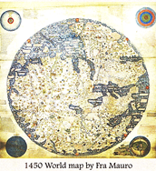
The art of prepay called cartography, and a person who prepares maps is called a cartographer. The Framauro map. One great medieval Europe map was made around 1450 by a Venetian monk Fra Mauro. It is a circular world maps drawn on parchment depicting Asia. Africa and Europe. This is said to be the first map for the known world.
TYPES OF MAPS
Maps can be classified in many ways, but two of them are most useful. One classification is based on the scale of the map and the other on environments or function. A Map can be large scale or small scale depending on the ratio of distance on the map to the distance on the ground.
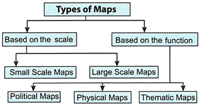
Maps based on Scale
Small Scale Maps Small Scale Maps show a large area such as that of a continent or country. So, many minute details cannot be shown as there is less space on the map. Therefore, a small scale is used.
Large Scale Maps
Large Scale Maps show a very small area in detail. These maps are used to show layout maps of cities and villages.
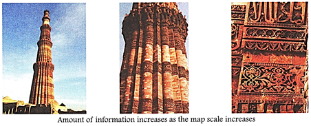
As the scale increases, detailing of information on the map also increases. When map scale is small, it covers larger area with lesser detailing. When the scale of the map is large, it can show much detailed information of the area shown in the map. For example, topographical maps are large scale maps in which we can see natural and man- made features both. But, a map of a country or the world map is a small scale map, in which we can find only the boundaries of the administrative units and their capitals. You can understand this with the given example where detailing of the monument increases as the scale increases.
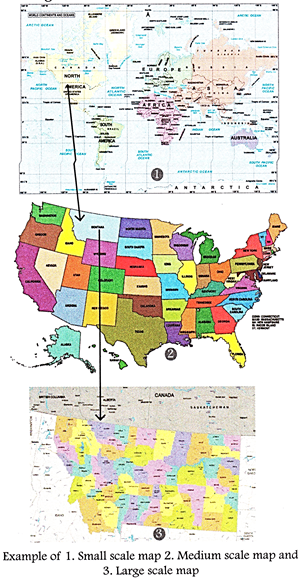
As the ratio between actual distance of ground and map increases areal coverage reduces bur detailing of information increases.
Maps based on functions
Another classification of maps can be done according to their function or the features shown on them. These are: (i)
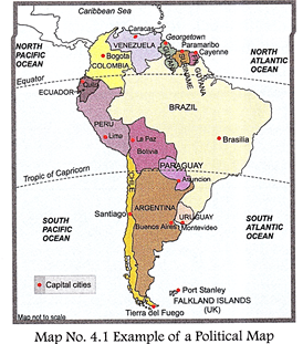
Political Maps
(ii) Physical Maps, and (iii) Thematic Maps. Political Maps Political Maps show countries and their political units (states, districts, etc.) with boundaries.
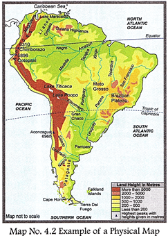
Physical Maps
Physical Maps show relief features of the earth's surface, e.g. mountains, plateaus, plains, valleys, rivers and oceans. These maps help in finding sites for settlements, buildings, roads and railways, and even construction sites for dams, etc.
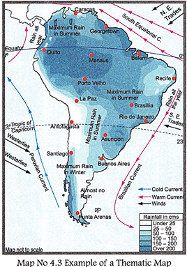
Thematic Maps
Thematic Maps show specific types of features such as roads, air routes, railways, climatic elements (rainfall, temperature, air-pressure), distribution of population, mining areas and industries.
Geography Reveals
The earliest known maps are of the stars, not the earth. Dots dating to 16,500 B.C. found or the walls of the LASACAUX Caves, map out part of the night sky; including three bright stars VEGA, DENEB and the ALTAIR, as well as the PLEIADES star cluster. A map like representation of a mountain, river, village and routes around PAULOU in the Czech Republic has been dated back to 25,000 B.C. Every map has three
COMPONENTS OF A MAP
Every map has three basic components: (i) Direction (ii) Distance between two places i.e. scale and (iii) Conventional signs and symbols.
Directions
The north direction is always clearly marked on maps by a letter 'N' or by showing an arrow \[(\uparrow )\] in the north direction. If there is no sign, then the top edge of the map should be taken as north. The other directions like south, east and west are thus found out.
A compass is used to show directions. It has a magnetised needle which spins around an axis on which it is fitted. The magnetised needle stands still in the north-south direction. The magnetic compass is also called Mariners compass as it is used by sailors.
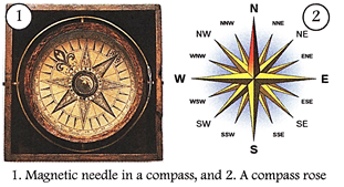
A compass has four main points known as cardinal points. These are, in fact, four major directions: North, South, East and West.
In between these four cardinal points lie some inter-cardinal points. All these cardinal and inter-cardinal points together make a rose-like structure called the compass rose. Travellers, navigators and pilots use the compass rose.
Distances on a Map (Scale)
Maps are a reduced representation of the earth or its parts on a flat surface. This reduction in length and size on a map is done in a fixed ratio. For example, if we have to show the real distance of two places on the earth as 1 kilometre (1,00,000 centimetres), we may take a scale of 1 centimetre to represent 1 kilometre on the map. This scale is maintained throughout the map. On maps scales are shown in these three ways.
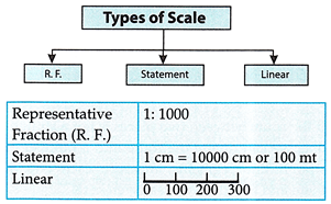
Thus, a scale is the reduced value of distance on maps. Ratio between the map distance and the ground distance is called the scale of a map. Distances either on the ground or on maps are measured by drawing a straight line, as shown in the following example.
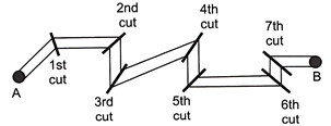
Activity
Study the drawings below and complete the sentences that follow. One has been done for you. (Refer to the directions above)
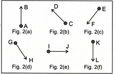
In Fig. 2(a), B is north to A.
In Fig. 2(b)/D is ............ to C.
InFig.2(c)/F is ............ to E.
In Fig. 2(d), His ............ to G.
In Fig. 2(e)/J is ............ to I.
In Fig. 2(f)/L is ............ to K.
2. Study the map and give the correct directions of the following.
? From Port A to the Rocks: ............
? From the Wreck to the Oil rigs: ............
? From the Oil rigs to the Rocks: ............
Thus, a scale is the reduced value of distances on maps. The ratio between the map distance and the ground distance is called the scale of a map. Distances either on the ground or on maps are measured by drawing a straight line, as shown in the following example
.
? From Port B to the Wreck: ............
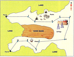
3. The ship you own has landed its cargo at Port A. It must go to Port B to reload. The course (directions) which the ship has to follow is shown by the dotted line. You have to give the captain of the ship compass-directions to follow the numbered route points.
Help: You may start your instructions in this way:
? Leave Port A, and go straight east to Point 1.
? Leave Point 1, and go south-east to Point 2.
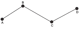
If the route between two places is nor a straight line, we can divide the route into a number of straight- line segments, measure each one of them and add them up, as given here.
Straight-line distances can be measured simply by using either (i) a ruler, or (ii) a pair of dividers and a ruler. However, the curved-line distances can be measured by using a string and a ruler.
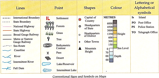
Conventional Signs and Symbols on Maps
A map must be clear and easy to read because every map shows and records a variety of information. This information may be political boundaries, climatic conditions, relief features, distribution of natural resources as well as population density, railways, airways, sea routes, roadways, various social and physical features, cities, towns, etc. So, there is always a chance that a lot is put on the map and it becomes crowded. Therefore, different signs and symbols are used to save space and to keep maps clean. Thus, seeing and identifying things on maps become easier. These signs and symbols can be in the form of small drawings, lines, letters, short words or coloured areas. Symbols used on a map are explained in a key. The same symbols are used in every part of the world. These map symbols are also called conventional symbols. Different colours are used to indicate different features or things on a map. For example, blue is used for showing water, brown for mountains, yellow for agriculture and green for vegetation; red colour is used to show roads, cart tracks, and footpaths; railways and boundaries are shown in black; settlements (both temporary and permanent) are shown in red; Post offices, Post and Telegraph Offices, and Police Stations are abbreviated as PO, PTO and PS respectively.
Geography Reveals
The first atlas was Published by Mercator in 16 Century C.E. He named the book of maps as Atlas. This name was given after a Greek mythological character 'Atlas?, who is believed to support and carry the earth on his shoulders.
Thus, the information provided on a map can be understood easily if we are acquainted with the three map features, i.e. distance (scale), direction, and conventional signs and symbols.
SKETCH, PLANS AND MAPS
A Sketch Map is a map that shows outlines of an area without providing enough details. A Sketch Map can be drawn without using a scale. It is a rough drawing and the distances are not accurate according to any scale.
A Plan, on the other hand, is a representation of an area with reduced measurement (scale).
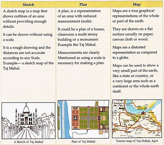
It could be the plan of a house, classroom or even a multi-storey building. Measurements are clearly mentioned as using a scale is necessary for making a plan.
Imagine that you are in a hot-air balloon looking down at the ground below you what would you see? There would be buildings, roads, parks, fields maybe forest, rivers, streams, hills or mountains. These features can be map; used to draw a sketch, a plan or ever a map representing a view of part of the Earth's surface.
Lets find out how a sketch, a plan or a map are different and how each one is useful to us and when they can be used. Study the box info given below.
After studying the table you would have realized that maps are a richer source of reformation as, compared to a sketch map or a plan even a globe Maps are extremely helpful to us as they answer some very basic geographic question which we all ask like-Where exactly am I? How can I find my way? Where am I going or even What are the various places that I will be passing through my journey before I reach my destination?
When a map isn't enough
You are holidaying with your family in the Thar desert, A sandstorm covers the vehicle track you were following, and even the landmarks on your map can't be seen! But thankfully your four wheel drive is fitted with a GPS!! The GPS Our global Position System Also know as NAVSTAR; is a satellite based system that allows the operates to locate a person's positions on the earth accurately within a few minutes.
It is made up of a network of 24 satellites placed in orbit by the US department of defence in 1975. But it was made available for civilian use in the 1980's. For land based users, the GPS maps have on enormous range of data including your location in weather conditions emergency centres, and accommodation. Getting lost is going to be harder in the future!!


You need to login to perform this action.
You will be redirected in
3 sec

