Solved papers for 12th Class Geography Solved Paper - Geography 2017 Outside Delhi Set-I

done Solved Paper - Geography 2017 Outside Delhi Set-I Total Questions - 22

  • question_answer1) State the two groups of factors which affect the profitability of mining.

    View Answer play_arrow
  • question_answer2) Which country of the world has the highest road density?

    View Answer play_arrow
  • question_answer3) Name any two garrison (cantonment) towns of India.

    View Answer play_arrow
  • question_answer4) Why is West Asia the least developed in rail facilities? Explain one reason.

    View Answer play_arrow
  • question_answer5) Examine the twin environmental problems that have emerged in the 'Indira Gandhi Canal Command Area'.

    View Answer play_arrow
  • question_answer6) Classify minerals on the basis of chemical and physical properties.

    View Answer play_arrow
  • question_answer7) How can you help in improving the quality of water in your locality?

    View Answer play_arrow
  • question_answer8) 
    Study the map given below carefully and answer the questions that follow:
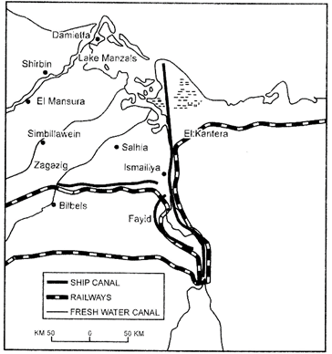
    (1) Identify and name the canal shown in the map.
    (2) Write any four characteristics of this canal.

    View Answer play_arrow
  • question_answer9) Describe any three characteristics of chain stores in the world.

    View Answer play_arrow
  • question_answer10) 
    Study the diagram given below and answer the questions that follow:
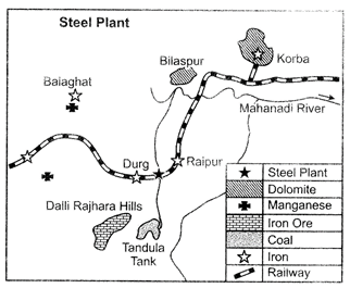
    (i) Identify and name the steel plant given above. In which State this plant located?
    (ii) Which is the main source of power for this steel plant? Which rail route provides transport facilities to this plant?
    (iii) What are the major sources of Iron-ore and water for this steel plant?

    View Answer play_arrow
  • question_answer11) 'There is no consensus on what exactly defines a village or a town.? Analyse the statement by using different criteria.

    View Answer play_arrow
  • question_answer12) 'Nature provides opportunities and humans make use of these and slowly nature gets humanised and starts bearing the imprints of human endeavour.' Justify the statement.

    View Answer play_arrow
  • question_answer13) 'Indiscriminate use of water by increasing population and industrial expansion has led to degradation of the water quality considerably in India.' Explain the values that can help in maintaining the quality of water.

    View Answer play_arrow
  • question_answer14) Mention any four major objectives of the New Industrial Policy, 1991 of India. Describe the role of globalization in achieving these objectives.

    View Answer play_arrow
  • question_answer15) 'The size of a territory and per capita income are not directly related to human development.' Support the statement with examples.

    View Answer play_arrow
  • question_answer16) How is migration a response to the uneven distribution of opportunities over a space? Explain the economic consequences of migration in India.

    View Answer play_arrow
  • question_answer17) 'In Modern times international trade is the basis of the world economy.' Support the statement with examples.

    View Answer play_arrow
  • question_answer18) Review any five measures adopted to solve the problems of Indian agriculture.

    View Answer play_arrow
  • question_answer19) Classify intensive subsistence agriculture into two categories practised in the world. How are they different from each other? Explain.

    View Answer play_arrow
  • question_answer20) Classify means of communication on the basis of scale and quality into two categories. Explain any two characteristics of each category.

    View Answer play_arrow
  • question_answer21) 
    Identify the five geographical features shown on the given political outline map of the World as A, B, C, D and E and write their correct names on the lines marked near them with the help of the following information:
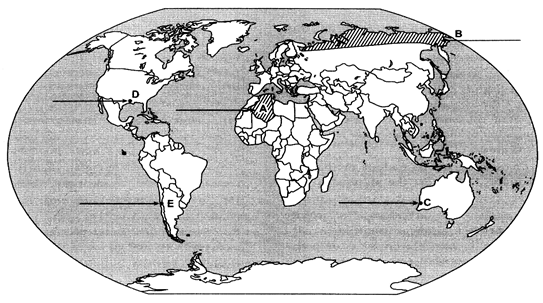
    (A) A large country of Africa in terms of area
    (B) A major area of subsistence gathering
    (C) The terminal station of a 'Transcontinental Railway'
    (D) A major seaport
    (E) An international airport

    View Answer play_arrow
  • question_answer22) 
    Locate and label the following features with appropriate symbols on the given outline political map of India:
    (i) The state having the highest density of population according to Census 2011.
    (ii) The leading rice producing state.
    (iii) The software technology park located in Gujarat.
    (iv) The major coalfield located in Odisha.
    (v) An international airport located in Tamil Nadu.

    View Answer play_arrow

Study Package

Solved Paper - Geography 2017 Outside Delhi Set-I


You need to login to perform this action.
You will be redirected in 3 sec spinner