Solved papers for 12th Class Geography Solved Paper - Geography 2013 Outside Delhi Set-I

done Solved Paper - Geography 2013 Outside Delhi Set-I Total Questions - 26

  • question_answer1) Name the most densely populated region in North America.

    View Answer play_arrow
  • question_answer2) Give the meaning of Age-sex structure of population.

    View Answer play_arrow
  • question_answer3) Which highway connects North America to South America?

    View Answer play_arrow
  • question_answer4) What are naval ports? Give one example of naval port.

    View Answer play_arrow
  • question_answer5) Define the term 'tetriary activities'.

    View Answer play_arrow
  • question_answer6) Give any two examples of 'quaternary activities'.

    View Answer play_arrow
  • question_answer7) Give the meaning of 'clustered rural settlement' in India.

    View Answer play_arrow
  • question_answer8) State the main functions of 'Border Roads Organization' (BRO).

    View Answer play_arrow
  • question_answer9) Name the major seaport located on Hugli River.

    View Answer play_arrow
  • question_answer10) Mention any two sources of land pollution in India.

    View Answer play_arrow
  • question_answer11) Define 'Human Geography' in your own words. Mention any four fields of human geography.

    View Answer play_arrow
  • question_answer12) Describe three main sources of noise pollution in India.

    View Answer play_arrow
  • question_answer13) Describe any three advantages of water transport in the world.

    View Answer play_arrow
  • question_answer14) Explain any three characteristics of modern large scale manufacturing in the world.

    View Answer play_arrow
  • question_answer15) Explain any three characteristics each of hamleted and dispersed rural settlement in India.

    View Answer play_arrow
  • question_answer16) Explain any three features of 'dry land farming' in India.

    View Answer play_arrow
  • question_answer17) Examine any three causes for the deterioration of 'quality of water' in India.

    View Answer play_arrow
  • question_answer18) Give two advantages of 'wind energy'. Mention four states of India having favourable conditions for the development of wind energy.

    View Answer play_arrow
  • question_answer19) Analyse any three locational factors which helped in the development of ?Hugli Industrial Region?.

    View Answer play_arrow
  • question_answer20) 'Equity is one of the most important pillars of human development,' Explain, any three human values that are required to give equal access to opportunities to everybody.

    View Answer play_arrow
  • question_answer21) 
    Study the given map, showing dairy farming regions, carefully and answer the following questions:
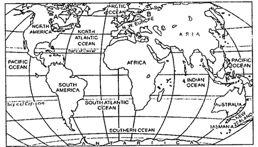
    (i) Identify and name the areas A and B, marked on the map.
    (ii) Define 'dairy farming'.
    (iii) Explain any three characteristics of dairy farming.
     

    View Answer play_arrow
  • question_answer22) Explain the two types of international trade. Examine any three possible negative impacts of globalization along with free trade in the world.

    View Answer play_arrow
  • question_answer23) Explain any five factors that affect the location of rural settlements of the world.

    View Answer play_arrow
  • question_answer24) Examine any five push factors that cause 'migration of population' in India.

    View Answer play_arrow
  • question_answer25) What are National Highways? Explain any four uses of National Highways in India.

    View Answer play_arrow
  • question_answer26) 
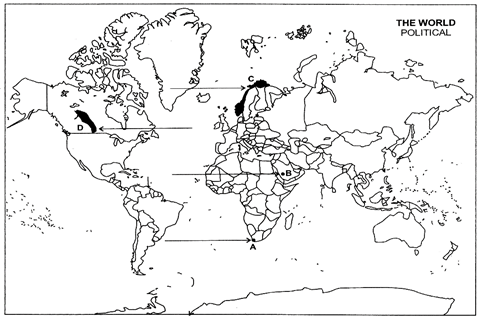
    (a) In the given political outline map of the world, four features have been marked as A, B, C and D. Identify these features with the help of following information and write their correct names on the lines drawn near them.
    A. A major sea port
    B. A major airport
    C. The country having highest rank in Human Development Index.
    D. An area of extensive commercial grain farming.
    (b) Locate and label the following on the political outline map of India with appropriate symbols.
    (i) A state having highest literacy rate.
    (ii) A copper mining area of southern Jharkhand.
    (iii) Headquarter of North-Western Railway Zone.

    View Answer play_arrow

Study Package

Solved Paper - Geography 2013 Outside Delhi Set-I


You need to login to perform this action.
You will be redirected in 3 sec spinner