Solved papers for 12th Class Geography Solved Paper - Geography 2018

done Solved Paper - Geography 2018 Total Questions - 22

  • question_answer1) Differentiate between growth and development.

    View Answer play_arrow
  • question_answer2) Why is India a popular tourist destination in the world?

    View Answer play_arrow
  • question_answer3) Evaluate the importance of 'quaternary activities'.

    View Answer play_arrow
  • question_answer4) Examine the concept of 'regional planning'.

    View Answer play_arrow
  • question_answer5) Mention any two factors responsible for the establishment of cotton textile mills in Mumbai.

    View Answer play_arrow
  • question_answer6) State the major problem being faced by Kolkata seaport.

    View Answer play_arrow
  • question_answer7) State any two advantages of air transport in the International trade.

    View Answer play_arrow
  • question_answer8) 'The primitive communities lived in complete harmony with their natural environment and as such the humans were naturalised.' Support the statement.

    View Answer play_arrow
  • question_answer9) Differentiate between small scale manufacturing and large scale manufacturing.

    View Answer play_arrow
  • question_answer10) Describe any three major problems of road transport in the world.

    View Answer play_arrow
  • question_answer11) 
    'Every January after the harvest season 'Jonbell Mela' takes place in Jagiroad, 35 kilometres away from Guwahati and it is possibly the only fair in India, where 'barter system' is still alive, A big market is organized during this fair and people from various tribes and communities exchange their products.?
    In the light of the above paragraph, justify the values of 'barter system' in the lives of tribal communities.
     

    View Answer play_arrow
  • question_answer12) 
    Study the diagram given below and answer the questions that follow:
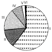
    (i) Which class of towns/cities support largest urban population?
    (ii) Explain any two reasons for such a high concentration of population in this class of towns/cities.

    View Answer play_arrow
  • question_answer13) 'Indiscriminate use of water by increasing population and industrial expansion has led to degradation of the quality of water considerably.' Evaluate the statement.

    View Answer play_arrow
  • question_answer14) Define the term 'density of population'. Explain four geographical factors affecting the distribution of population in the world, with examples.

    View Answer play_arrow
  • question_answer15) 'Gathering and hunting are the primitive economic activities meant for the subsistence of tribal societies, but in modern times gathering is market oriented and has become commercial.' Examine the statement.

    View Answer play_arrow
  • question_answer16) 
    Study the following map of the Suez Canal carefully and answer the questions that follow:
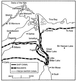
    (i) Name the country through which this canal passes.
    (ii) Name the seas connected by this canal.
    (iii) Why is the canal considered a gateway of Europe to the Indian Ocean?

    View Answer play_arrow
  • question_answer17) 'The decadal and annual growth rates of population in India are both very high and steadily increasing over time.' Substantiate the statement.

    View Answer play_arrow
  • question_answer18) Explain how 'watershed management' and 'rainwater harvesting' are the methods of efficient management and conservation of surface water resources in India.

    View Answer play_arrow
  • question_answer19) 'The non-conventional sources of energy will provide more sustained, eco-friendly and cheaper energy if the initial cost is taken care of.' Examine the statement.

    View Answer play_arrow
  • question_answer20) Describe any five characteristics of National Highways of India.

    View Answer play_arrow
  • question_answer21) 
    Identify the five geographical features shown on the given political outline map of the World as A, B, C, D and E and write their correct names on the lines marked near them with the help of the following information:
    A. A major sea-port                                          B. An international airport
    C. A major industrial region                             D. An important area of nomadic herding
    E. A mega city

    View Answer play_arrow
  • question_answer22) 
    Locate and label the following features with appropriate symbols on the given political map of India.
    (i) A major tea growing state
    (ii) Mayurbhanj - An area of iron ore mining
    (iii) An important steel plant in Karnataka
    (iv) An international southernmost airport in Kerala
    (v) A city with a population of more than ten million in North India.

    View Answer play_arrow

Study Package

Solved Paper - Geography 2018


You need to login to perform this action.
You will be redirected in 3 sec spinner