Notes - Our Ever Changing Earth
Category : 7th Class
Our Ever Changing Earth
After the condolence meeting for the victims of the Nepal earthquake, Meghna and Kartik were discussing as to why certain areas around the earth are prone to earthquakes, volcanic eruptions and tsunamis. Both of them realised that there is one person who would have the answers and that would be their Geography teacher. She explained to them at length.
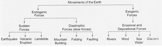
MOVEMENTS OF EARTH SURFACE
In the previous chapter, we have learnt that the lithospheric plates are broken like an eggshell and these tectonic plates float on the molten magma in the asthenosphere. Movements of these plates is as slow as few millimetres in a year. Still it changes the earth's surface. But this is not the only reason, there are external forces as well, that lead to changes on the earth's surface. Forces which affect the earth's surface from its interior are called Endogenic forces, and which affect the earth's surface from outside are called Exogenic forces.
CAUSES OF MOVEMENT
You must be surprised and thinking that how such a small scale movement can change our lithosphere to such a large extent? And what actually causes this movement? It has been discussed and mentioned earlier that core of our earth is not solid and even the upper mantle is semi-solid or semi-molten. As we go deeper, temperature increases with the increasing depth. If it is around 1600°C At asthenosphere, it is around 6000°C in the core. The heat from the core generates the convectional current in the mantle. Rising current of heated magma reaches the top, cools down again to become heavy and sinks. This cycle of moving up and sinking down of magma causes, movements in slow motion in the tectonic plates; that float on the asthenosphere.
As we mentioned in the previous chapter that there are six major and twenty minor plates on
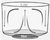
Convection is a process of heat transfer of liquids and air. Heated air or fluid moves up. As they reach up to the surface, they start loosing their heat and cool down. Then they sink back from the corners and complete the circular motion. A similar process is found in the middle layer of the mantle, due to which magma moves upward and causes movement of the plates.
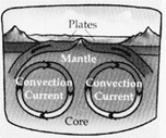
The crust. Although these plates are made up of solid rocks but they float on the molten magma of asthenosphere as they are lighter in density in comparison to the mantle. Distribution and direction of movements of these plates is given in Map No. 3.1.
Geography Reveals
A theory related to Continental Drift was proposed by Alfred Lothar Wegner in 1912 which was later modified and replaced by the Theory of Plate Tectonics.
In this map you will find different types of plate margins. They are i) Destructive ii) Constructive and iii) Conservative. When two plates move towards each other, they collide and the heavier plate subducts under the lighter plate. Such margins are named destructive plate margins. Constructive plate margins are found where material for new plates is continuously coming up from the interior of the earth. It happens when the two plates move away from each other and mostly ridges are formed there. Conservative margins are found where two plates pass each other side by side and no destruction or construction takes place.

EFFECTS OF ENDOGENIC FORCES
As we have discussed earlier that endogenic forces cause movements of the earth's crust. These movements can be slow or sudden. Sudden movements may lead to earthquakes, landslides and volcanic eruptions. Slow movements cause land folding and faulting as well as elevation (mountains) and depression (rift valleys) of the land. Here w well discuss about volcanoes and earthquakes only.
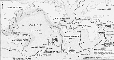
Map No. 3.1 Distribution of major plates and their plate margins
Geography Reveals
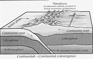
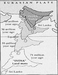
Do you know the highest mountain ranges of the Himalayas have been formed due to such movements of, the earth? The Himalayas are located at the destructive margins of the Indian Plate and the Eurasian Plate. Around 225 million years ago, there was only one landmass named as Pangaea. 25 million years later, it broke into two parts named "Gondwanaland"" and ''Lauresia''. Later on they were further divided in many parts and around 65 million years ago the Indian sub-continent, that lies on the Indian Plate started moving towards the north-east and collided with the Eurasian Plate, which caused large scale folding on the earth surface and created such high mountain ranges like the Himalayas.
Volcanoes
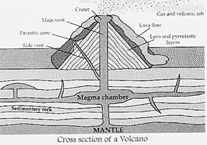
Volcanoes may erupt anytime without giving any warning in advance making them very dangerous. Volcanicity or volcanism refers to all the processes by which molten material (magma) is forced out of the interior of the earth through a vent. A vent is a fissure or fracture created in the crust leading it to the earth's surface. In the process of volcanic eruptions, lava, ash, rocks and gases come out through the crater creating gigantic fireworks and explosions. Their accumulation on the earth's surface creates volcanic mountains.
Basically three types of volcanoes are found. A volcano that stops erupting is said to be dormant or sleeping. If the vent or pipe of a volcano is sealed by the movement of the crust, the volcano becomes extinct, e.g., Mount Fuji in Japan and Mount Kilimanjaro in Africa. On the contrary, a volcano that erupts from time to time is called an active volcano.
Geography Reveals
The word 'Volcano' is derived from the name of an island in the Mediterranean Sea called Vulcano named after the Roman God Vulcan.
Geography Reveals
The only active volcano in India is Barren Island in the Andaman and Nicobar Islands.
Earthquakes
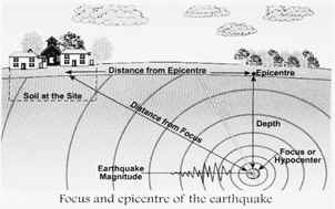
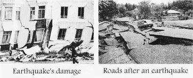
A sudden movement of the crustal plates causes earthquakes. This is due to enormous amount of pressure building up when crustal plates push against each other. Earthquakes are so powerful that buildings collapse, dams burst/ bridges fall, landslides occur and communication is disrupted. If an earthquake is intense, fires break out when the electricity wires and gas pipelines break and come into contact. Seismic waves or shock waves originate from a point that usually lies at the lower level of the crust. This point is called the focus. The point on the earth's surface that is exactly above the focus is called the epicentre. Vibrations travel outwards from the epicentre as shock waves. Greatest damage is usually closest to the epicentre. The strength of the earthquake decreases away from the centre.
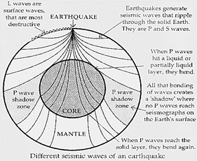
Types of earthquake waves?during an earthquake, several types of seismic waves are released from the focus. They all travel along the crust at different speeds and in different directions. They are mainly of three types
(i) Primary waves, and (ii) Secondary waves and (iii) Surface or land waves.
(a) Primary waves are also called longitudinal or compressional waves. They are the fastest moving waves and hence are the first to be recorded on a seismograph.
(b) Secondary waves are also called transverse waves, shake waves or shear waves.
(c) Surface waves travel on the earth's surface starting from the epicentre. They have the longest amplitudes and the longest periods and therefore, the greatest amount of wave energy. Surface waves are considered to be the most destructive seismic waves.
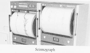
Measuring of an earthquake?Earthquakes cannot be predicted however an instrument that detects, measures and records an earthquake is called seismograph. Nowadays, the Kinemetrics Seismograph is used, which is fully computerised. Usually, two aspects of an earthquake are measured; i.e. its magnitude, and its intensity.
i. The magnitude of an earthquake is the total amount of energy released at the source (epicentre). This is measured on the Richter scale [ranging from 0 to 10 (in theory)].
ii. The intensity of an earthquake is the description of the earth's shaking in terms of the damage done on the earth's surface. The Mercalli scale is used to measure the earthquake's intensity. The Mercalli scale is divided from level I to XII.
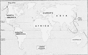
Q. why do you think the earthquake belts of the world coincide with the distribution volcanoes?
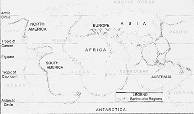
Map No. 3.3 Earthquake regions of the world
Tsunamis
Tsunamis are tidal waves triggered off by large underwater earthquakes. They occur on the ocean floors. They can travel across the ocean at a speed of up to 800 kilometers/hour. Usually tsunami waves occur at an interval of 15 minutes.
THE NEPAL EARTHQUAKE
The worst quakes of the century hit the Himalayan nation on April 25th and 12th May 2015. Nearly 32 nations and 75 districts were affected. The quake measured 7.8 and 7.3 on the Richter scale. Epicentre of the earthquake was near Kathmandu. Maximum Mercalli intensity of IX was recorder. Depth 18.5 km-being at a shallower depth/ the destructive power was disastrous. The Nepal earthquake took a huge toll of over 8000 people and injured more than 21,000. The Nepal earthquake damage billed at Rs.513 billion, income loss Rs.187 billion. After Effects were felt in
Bihar, U.P., West Bengal and even in Chennai, Bangladesh and Tibet (China). Nepal is situated along the fault line where the Indian tectonic plate moves towards the north with the speed of about 44 mm a year; pushing under the Eurasian plate beneath the Himalayas. Mount Everest moved more than an air inch south-west after this earthquake!!!
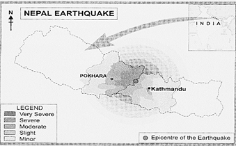
Map No. 3.4 Nepal Earthquake
When the waves approach shallow coastal Waters, they slowdown in speed but rise up rapidly in height; some are up to 15 meters high. These waves cause much destruction and loss of life in coastal areas.
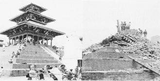
Darbar square, before and after the Kathmandu earthquake
EFFECTS OF EXOGENIC FORCES
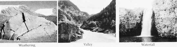
Exogenic forces that change the earth's surface (crust) from outside include: (i) Weathering, (ii) Erosion, (iii) Soil creep, and (iv) landslides.
Weathering is the breaking up of rocks. Soil creep occurs when soil slowly slides down a slope, which generally happens after heavy rains. A landslide occurs when soil and rocks rapidly rush down a mountain. In the daytime, rocks get heated under the Sun and at night, they cool down. Due to rapid and repeated heating and cooling, rocks develop cracks. These cracks widen further and finally break into smaller pieces or the outer layer can peel off in layers and is known as exfoliation. Small rock fragments are easily removed by the agents of nature, viz. wind, water and ice. This process is called erosion. The eroded material is eventually deposited at some other locations. The whole process of weathering, erosion and finally deposition of the weathered material to different locations create different landforms on the surface of the earth.
All these processes, on the other hand, show how exogenic forces help change the landscape.
Let us learn in detail how some forces (agents of nature) work.
Landforms made by Rivers
Rivers leave an impact on the shape of the earth's surface. As the river water flows down the steep land or mountain, a great amount of energy is generated that erodes the land. Together with the underlying rocks, the running water of the river produces many distinctive features such as valleys, waterfalls, gorges, flood plains, meanders, deltas, etc.
Geography Reveals
There are three stages during the course of a river from its origin in the mountains till the mouth at the sea. In the- upper or young stage of the river, erosion work is at its peak. Gradually when the river enters into the plains reaching its middle or mature stage, there occurs transportation of debris in huge amounts. At the last stage, when land is almost Hat with no gradient, deposition becomes the dominant work of the river.
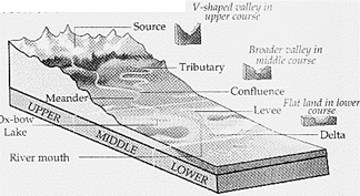
A river erodes the bed and banks of the channel in which it is flowing. Erosion of the river bed or river banks may take place vertically as well as sideways. This is called a valley. When a river reaches the edge of a cliff or plateau, a waterfall is created. It is a steep fall of a water body in
A river channel. The rock particles eroded from the mountains are eventually transported downstream and deposited all over the plains, making it much wider.
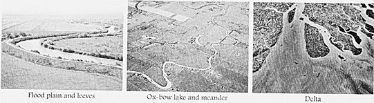
Deposited sediment leads to the formation of various features like floodplains, meanders and deltas. During heavy rains, a river overflows its channel and the water spreads over the nearby flat valley floors. The flood water carries small particles of rocks called sediment and spreads it over the plain. Year after year/ layers of sediment build up and form a floodplain. In this process, flooded rivers build up riverbanks also. Such raised riverbanks are called levees.
Geography Reveals
The Ganges plains in India, the Rhine plains in Western Europe, the Hwang-Ho plains in China, and the Mississippi plains in the USA are floodplains with rich fertile soil.
As a river flows over a gentle slope when it reaches the plains on its middle course; it forms a series of loops called meanders. These meanders frequently change their shape and location, due to the continuous erosion and deposition. Over the period of time the meander loop cuts off from the river and forms a cut off lake, called as
Ox-bow lake.
As the river approaches the sea, the energy of a river gradually reduces in the last stage. The river water is unable to carry any sediment with it at this stage. So, the river starts depositing its sediment. Due to weak river currents, layers of sediment build up at the mouth of the river and the river channel is blocked with the sediment. The river is then forced to divide into a series of separate channels or distributaries that form a delta after some time. Gradually, plants start growing on the delta that support and stabilize it. When a river enters the sea without forming a delta, it is called an estuary.
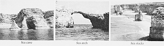
Landforms made by Sea Waves
Sea waves keep changing the form and shape of the coasts creating many coastal landforms. Sea waves, rocks (lying in and around the sea) and tides are main determining features that force the coastline to retreat and evolve. Less resistant rocks at the sea coast are eroded and certain rock features such as caves, arches and stacks are formed.
Cave, arches and stacks are landforms formed over a period of time. First cracks develop on the rock surface due to constant action of waves. With time, these cracks become larger and wider. As these cracks expand, they become hollow and finally form a cave. Sea waves constantly work on these rocks from all sides. Slowly only the upper roof remains as an arch and lower part form a see through cavity. Further, even these roofs and arches are not spared by the erosional work of the sea waves and they collapse. Now only a pillar like feature remains which is separate from the main land after the eroded arch falls. This is called a stack which erodes and vanishes over a long period of time. Various coastal landforms and sea beaches attract tourists and holiday-makers for swimming, surfing/ and other sports.
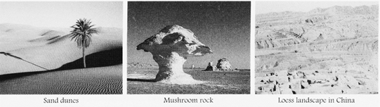
Landforms made by Winds
Wind is responsible for erosion in deserts. When it blows across the land, it picks up tiny particles of loose sand. These sand particles strike forcefully against rocks in case of strong winds or storm. This is called sandblast. Constant wind action shapes the outer surface creating different landforms in deserts, such as Mushroom rock known as Pedestal rock. Winds erode the lower soft part of the rocks more quickly as compared to the top giving the rock a mushroom shape. When sand is deposited at a place, sand dunes are formed. Sometimes, sand is carried away to a distant location that is not a part of the desert. Sand is deposited therein to create a unique structure called loess. Loess covers large areas in China.
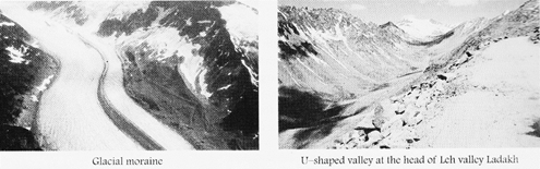
Landforms made by Glaciers
In the regions of cold climate, new and fresh snowfall turns the underlying snow into ice. When ice moves downhill under the force of gravity, it is called a glacier. A glacier is thus, a river of ice. Like river water, the ice of glaciers picks up and transports large amounts of material called moraine. As the material or moraine moves downhill, it erode the land, forming new landforms. Later, the moraine is deposited in valleys and across the lowland.
A glacier valley is deeper, wider and more straightened than a river valley. The V-shaped valley turns into a U-shaped valley after glaciation. Glaciation is the modification of the land surface by the action of glaciers.
Many glaciated areas are now developed as national parks to conserve and enhance the natural beauty. People enjoy leisure activities such as skiing and hiking in these areas.
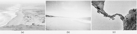
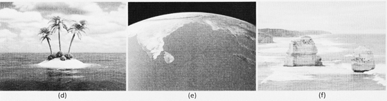
Activity
Given below are the pictures and descriptions of some coastal landforms and features formed by the work of sea. Match them and put the figure numbers in the blanks on the chart.
|
Term |
Description |
Fig. No. |
|
Dune |
A pile of sand behind a beach |
|
|
Beach |
The sandy zone along the shore where land meets sea |
|
|
Isthmus |
A narrow neck of land (surrounded by sea) joining two landmasses |
|
|
Island_ |
A small landmass surrounded by water |
|
|
Bay_ |
A small body of water largely enclosed by land |
|
|
Stack |
A rock separated from a headland |
|


You need to login to perform this action.
You will be redirected in
3 sec

