Solved papers for 12th Class Geography Solved Paper - Geography 2014 Outside Delhi Set-I

done Solved Paper - Geography 2014 Outside Delhi Set-I Total Questions - 26

  • question_answer1) Give the meaning of 'Age Structure'.

    View Answer play_arrow
  • question_answer2) Which country has proclaimed 'Gross National Happiness' as the measure of a country's progress?

    View Answer play_arrow
  • question_answer3) What is the meaning of 'Cyber-space'?

    View Answer play_arrow
  • question_answer4) Name the most important inland waterway of Germany.

    View Answer play_arrow
  • question_answer5) Which state of India has the highest rank in Human Development Index (H.D.I.) value?

    View Answer play_arrow
  • question_answer6) Name the 'urban agglomeration' having the highest share of immigrant population in India.

    View Answer play_arrow
  • question_answer7) Give an example of an ancient historical town from Bihar.

    View Answer play_arrow
  • question_answer8) Define the term 'watershed management'.

    View Answer play_arrow
  • question_answer9) What is 'satellite communication'?

    View Answer play_arrow
  • question_answer10) Mention any two diseases caused by contaminated water.

    View Answer play_arrow
  • question_answer11) Explain with examples, how nature gets humanized.

    View Answer play_arrow
  • question_answer12) Describe any three characteristics of the last stage of 'Demographic Transition Theory'.

    View Answer play_arrow
  • question_answer13) 
    Study the map given below and answer the questions that follow
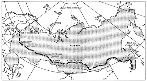
    (i) Identify and name the railway line shown on the map.
    (ii) Name the continents linked by this rail route.
    (iii) Explain how this railway line is helpful for the promotion of trade in this region.

    View Answer play_arrow
  • question_answer14) 'The decades 1951-81 are referred to as the period of population explosion in India.' Explain the statement by giving any three reasons.

    View Answer play_arrow
  • question_answer15) Give the meaning of 'dispersed settlement'. Explain any two reasons for the development of such settlements in India.

    View Answer play_arrow
  • question_answer16) 
    Study the diagram given below showing the location of a major steel plant in India and answer the questions that follow:
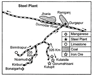
    (i) Identify and name the steel plant shown in this diagram.
    (ii) ?Name two coal-fields which supply coal to this plant.
    (iii) Mention the source of water Rupnh" for this plant

    View Answer play_arrow
  • question_answer17) 'The distribution of roads in India is not uniform'. Examine the statement giving three reasons.

    View Answer play_arrow
  • question_answer18) 'Most of Indians foreign trade is carried through sea routes'. Explain the statement giving three reasons.

    View Answer play_arrow
  • question_answer19) Describe any three major problems of slums in India.

    View Answer play_arrow
  • question_answer20) Explain any three social and economic values which encourage us to use more and more non-conventional sources of energy.

    View Answer play_arrow
  • question_answer21) Explain any five characteristics of 'extensive commercial grain cultivation' practised in the world.

    View Answer play_arrow
  • question_answer22) Define the terms 'manufacturing'. Explain any four features of 'small scale manufacturing'.

    View Answer play_arrow
  • question_answer23) Why are ports known as 'gateways' of international trade? Explain any three characteristics of inland ports.

    View Answer play_arrow
  • question_answer24) Explain any five major problems of the rural settlements in the developing countries of the world.

    View Answer play_arrow
  • question_answer25) Analyse any five major problems of Indian agriculture.

    View Answer play_arrow
  • question_answer26) 
    (i) In the given political outline map (on page) of the World, four features A, B, C and D have been shown. Identify these features with the help of the information given below and write their correct names on the lines drawn near them:
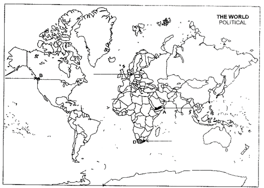
    A The country with the highest growth rate of population (1995-2000) in Asia
    B A terminal station of Trans-Canadian railway line
    C An important sea port
    D An area of extensive commercial grain farming
    (ii) On the given political outline map (on page) of India, locate and label the following with appropriate symbols:
    A The state having the highest percentage of urban population
    B The leading state in the production of tea
    C The international airport in Tamil Nadu

    View Answer play_arrow

Study Package

Solved Paper - Geography 2014 Outside Delhi Set-I


You need to login to perform this action.
You will be redirected in 3 sec spinner