Solved papers for 12th Class Geography Solved Paper - Geography 2014 Delhi Set-I

done Solved Paper - Geography 2014 Delhi Set-I Total Questions - 26

  • question_answer1) Define the term 'quaternary activities'.

    View Answer play_arrow
  • question_answer2) Give the meaning of 'digital divide'.

    View Answer play_arrow
  • question_answer3) Name the seaports on each end of Suez Canal.

    View Answer play_arrow
  • question_answer4) Define the term 'road density'.

    View Answer play_arrow
  • question_answer5) Give any two examples of ancient towns of India.

    View Answer play_arrow
  • question_answer6) Name the country which is the largest trading partner of India.

    View Answer play_arrow
  • question_answer7) Name the seaport which was constructed to reduce the congestion at Kolkata port.

    View Answer play_arrow
  • question_answer8) Name the major seaport which was developed just after independence on the western coast of India.

    View Answer play_arrow
  • question_answer9) What is truck farming?

    View Answer play_arrow
  • question_answer10) Mention the root cause of 'acid rains'.

    View Answer play_arrow
  • question_answer11) 'There is mutual interaction between the elements of Physical Geography and Human Geography'. Support the statement with suitable examples.

    View Answer play_arrow
  • question_answer12) Describe any three characteristics of 'Household Industries'.

    View Answer play_arrow
  • question_answer13) 
    Study the map given below and answer the questions that follow:
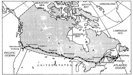
    (i) Name the railway line shown on this map.
    (ii) Name the terminal station of this railway along the Atlantic Coast.
    (iii) Why is this railway line known as 'economic artery' of the country through which it passes?
     

    View Answer play_arrow
  • question_answer14) Differentiate between rural and urban settlements of India in three points.

    View Answer play_arrow
  • question_answer15) State any two characteristics each of the three distinct 'cropping seasons' of India.

    View Answer play_arrow
  • question_answer16) Explain any three main characteristics of mineral resources of India.

    View Answer play_arrow
  • question_answer17) Describe any three advantages of satellite communication in India.

    View Answer play_arrow
  • question_answer18) Why is the 'Urban Waste Disposal' a serious problem in India? Explain any three reasons.

    View Answer play_arrow
  • question_answer19) 
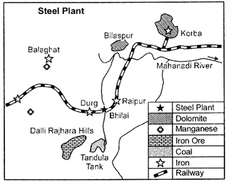
    Study the diagram given below, showing the location of an important steel plant in India, and answer the questions that follow:
    (i) Identify the steel plant and name it.
    (ii) Mention the thermal power plant which supplies power to it.
    (iii) Mention the source of water for this plant.

    View Answer play_arrow
  • question_answer20) Analyse the economic and social values of rainwater harvesting.

    View Answer play_arrow
  • question_answer21) Explain the three components of population change in the World. Analyse the impacts of population change.

    View Answer play_arrow
  • question_answer22) Describe any five characteristics of 'Commercial Livestock Rearing' practised in the world.

    View Answer play_arrow
  • question_answer23) Differentiate between bilateral trade and multilateral trade. Explain how ports are helpful in trade.

    View Answer play_arrow
  • question_answer24) Describe any five patterns of rural settlements in the world on the basis of forms of shapes. 

    View Answer play_arrow
  • question_answer25) 'The decades 1921-51 are referred to as the period of steady growth of population whereas the decades 1951' 1981 are referred to as the period of population explosion in India?. Explain giving reasons.

    View Answer play_arrow
  • question_answer26) 
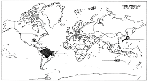
    (i) In the given political outline Map of the world four features A, B, C and D have been shown. Identify these features with the help of information given below and write their correct names on the lines drawn near them.
    A: An important sea port
    B: A terminal station of Australian Trans-Continental Railway
    C: An Area of subsistence gathering
    D: The country with lowest growth rate of population (1995-2000) in Asia.
    (ii) On the given political outline Map of India, locate and label the following with-appropriate symbols:
    A. The state having highest literacy rate.
    B. The leading state in the production of Jute.
    C. The northern most international airport.

    View Answer play_arrow

Study Package

Solved Paper - Geography 2014 Delhi Set-I


You need to login to perform this action.
You will be redirected in 3 sec spinner