0
question_answer1) Identify and locate the following with the help of map reading: (i) Kanchenjunga Range. (ii) Plateau lying between Aravallis and Vindhya ranges. (iii) The western and the eastern edges of the Peninsular Plateau. (iv) The eastward extension of the Central Highlands, rich in mineral resources. (v) Highest peak of Peninsular Plateau. (vi) The Western and the Eastern coastal stretches. (vii) North Western edge of the Deccan Plateau. (viii) Passes of the eastern and western Himalayas.
question_answer2) On an outline map of India, mark and label the following: (i) Mountain and hill range. : Karakoram. Zaskar, Nilgiri, Aravalli, Patkaibum. Garo, Khasi, Satpura, Vindhyachal, Cardamom, Ladakh. (ii) Peaks: K2, Anai Mudi, Nanga Parbat, Namcha Barwa, Nanda Devi. (iii) Rivers: Indus, Satluj, Brahmaputra, Ganga, Tapi, Narmada, Godavari, Krishna, Kaveri, Mahanadi. (iv) Plateau.: Malwa, Chota Nagpur, Shillong, Bundclkhand, Rann of Kachchh. (v) Coast: Konkan coasl, Malabar coast Coromandel coast.
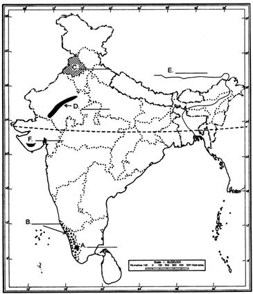
question_answer3) On the outline map of India six geographical features A. B, C, D, E, and F are marked. Identity these features with the help of the map key and write their. Correct names on the line marked against each of it in the map. (A) Peak (B) Coastals Plains (C) A State (D) Mountain Range (E) River (F) Hills Range
Please Wait you are being redirected....
You need to login to perform this action.You will be redirected in 3 sec
OTP has been sent to your mobile number and is valid for one hour
Your mobile number is verified.