NCERT Extracts - Oceans and Continents
Category : UPSC
Continental Drift
- Continents cover 29 per cent of the surface of the earth.
- Observe the shape of the coastline of the Atlantic Ocean. You will be surprised by the symmetry of the coastlines on either side of the ocean. No wonder, many scientists thought of this similarity and considered the possibility of the two Americas, Europe and Africa, to be once joined together.
- It was Alfred Wegener - a German meteorologist who put forth a comprehensive argument in the form of "the continental drift theory" in 1912.
- This was regarding the distribution of the oceans and the continents.
- According to Wegener, all the continents formed a single continental mass and Mega Ocean surrounded the same.
- The super continent was named Pangaea, which meant all earth.
- The mega-ocean was called Panthalassa, meaning all water.
- He argued that, around 200 million years ago, the super continent, Pangaea, began to split.
- Pangaea first broke into two large continental masses as Laurasia and Gondwanaland forming the northern and southern components respectively.
- Subse-quently, Laurasia and Gondwanaland continued to break into various smaller continents that exist today.
- A variety of evidence was offered in support of the continental drift. Some of these are given below.
Evidence in Support of the Continental Drift
The Matching of Continents (Jig-Saw-Fit)
- The shorelines of Africa and South America facing each other have a remarkable and unmistakable match.
- It may be noted that a map produced using a computer programme to find the best fit of the Atlantic margin was presented by Bullard in 1964.
- It proved to be quite perfect. The match was tried at 1,000-fathom line instead of the present shoreline.
Rocks of Same Age Across the Oceans
- The radiometric dating methods developed in the recent period have facilitated correlating the rock formation from different continents across the vast ocean.
- The belt of ancient rocks of 2,000 million years from Brazil coast matches with those from western Africa.
- The earliest marine deposits along the coastline of South America and Africa are of the me Jurassic age.
- This suggests that the ocean did not exist prior to that time.
Tilllite
- It is the sedimentary rock formed out of deposits of glaciers.
- The Gondawana system of sediments from India is known to have its counter parts in six different landmasses of the Southern Hemisphere.
- At the base the system has thick tillite indicating extensive and prolonged glaciation.
- Counterparts of this succession are found in Africa, Falkland Island, Madagascar, Antarctica and Australia besides India,
- Overall tesemblance of the Gondawana type Sediments clearly demonstrate that these landmasses had remarkably similar histories.
- The glacial tillite provides unambiguous evidence of palaeoclimates and also of drifting of drifting of continents.
Placer Deposits
- The occurrence of rich placer deposits of gold in the Ghana coast and the absolute absence of source rock in the region is an amazing fact.
- The gold bearing veins are in Brazil and it is obvious that the gold deposits of the Ghana are derived from the Brazil plateau when the two continents lay side.
Distribution of Fossils
- When identical species of plants and animals adapted to living on land or in fresh water are found on either side of the marine barriers, a problem arises regarding accounting for such distribution.
- The observations that Lemurs occur in India, Madagascar and Africa led some to consider a contiguous landmass "Lemuria" linking these three landmasses,
- Mesosaurus was a small reptile adapted to shallow brackish water.
- The skeletons of these are found only in two localities : the Southern Cape province of South Africa and Iraver formations of Brazil.
- The two localities presently are 4,800 km apart with an ocean in between them.
Force for Drifting
- Wegener suggested that the movement responsible for the drifting of the continents caused by pole-fleeing force and tidal force.
- The polar-fleeing force relates to the rotation of the earth.
- You are aware of the fact that .the earth is not a perfect sphere; it has a bulge at the equator.
- This bulge is due to the rotation of the earth. The second force that was suggested Wegener - the tidal force - is due to the attraction of the moon and the sun that develops tides in oceanic waters.
- Wegener believed that these force would become effective when applied over many million years.
- However, most of scholars considered these forces to be totally inadequate.
Post-Drift Studies
- It is interesting to note that for continental drift, most of the evidence was collected from the continental areas in the form of distribution of flora and fauna or deposits like tillite.
- A number of discoveries during the post-war period added new information to geological literature.
- Particularly, the information collected from the ocean floor mapping provided new dimensions for the study of distribution of oceans and continents.
Convectional Current Theory
- Arthur Holmes in 1930s discussed the possibility of convection currents operating in the mantle portion.
- These currents are generated due to radioactive elements causing thermal differences in the mantle portion.
- Holmes argued that there exists a system of such currents in the entire mantle portion.
- This was an attempt to provide an explanation to the issue of force, on the basis of which contemporary scientists discarded the continental drift theory.
Distribution of Earthquakes and Volcanoes
- Study the maps showing the distribution of seismic activity and volcanoes.
- You will notice a line of dots in the central parts of the Atlantic Ocean almost parallel to the coastlines.
- It further extends into the Indian Ocean.
- It bifurcates a little south of the Indian subcontinent with one branch moving into East Africa and the other meeting a similar line from Myanmar to New Guiana.
- You will notice that this line of dots coincides with the midoceanic ridges.
- The shaded belt showing another area of concentration coincides with the Alpine- Himalayan system and the rim of the Pacific Ocean.
- In general, the foci of the earthquake in the areas of mid-oceanic ridges are at shallow depths whereas along the Alpine-Himalayan belt as well as the rim of the Pacific, the earthquakes are deep-seated ones.
- The map of volcanoes also shows a similar pattern.
- The rim of the Pacific is also called rim of fire due to the existence of active volcanoes in this area.
Plate Tectonics
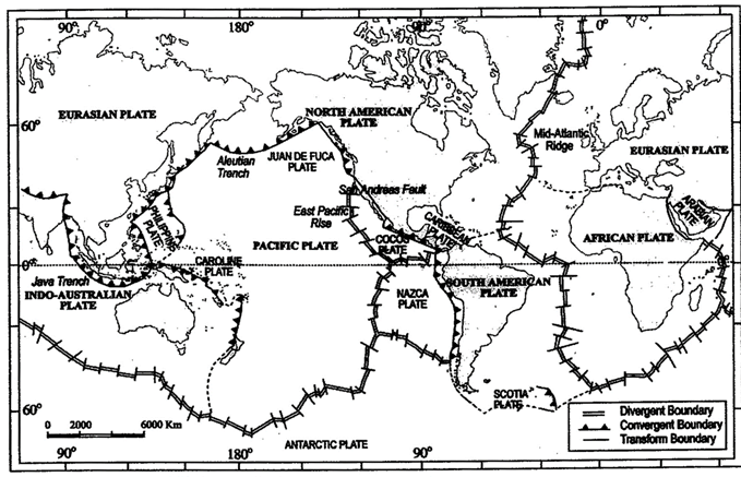
Major and minor plates of the world
- It was in 1967, McKenzie and Parker and also Morgan, independently collected the available ideas and came out with another concept termed Plate Tectonics.
- A tectonic plate (also called lithospheric plate) is a massive, irregularly-shaped slab of solid rock, generally composed of both continental and oceanic lithosphere.
- Plates move horizontally over the asthenosphere as rigid units.
- The lithosphere includes the crust and top mantle with its thickness range varying between 5-100 km in oceanic parts and about 200 km in the continental areas.
- A plate may be referred to as the continental plate or oceanic plate depending on which of the two occupy a larger portion of the plate.
- Pacific plate is largely an oceanic plate whereas the Eurasian plate may be called a continental plate.
- The theory of plate tectonics proposes that the earth's lithosphere is divided into seven major and some minor plates.
- Young Fold Mountain ridges, trenches, and/or faults surround these major plates.
The major plates are as follows :
- Antarctica and the surrounding oceanic plate
- North American (with western Atlantic floor separated from the South American plate along the Caribbean islands) plate
- South American (with western Atlantic floor separated from the North American plate along the Caribbean islands) plate
- Pacific plate
- India-Australia-New Zealand plate
- Africa with the eastern Atlantic floor plate
- Eurasia and the adjacent oceanic plate
Some important minor plates are listed below :
- Cocos plate: Between Central America and Pacific plate
- Nazca plate: Between South America and Pacific plate
- Arabian plate: "Mostly the Saudi Arabian landmass
- Philippine plate: Between the Asiatic and Pacific plate
- Caroline plate: Between the Philippine and Indian plate (North of New Guinea)
- Fuji plate : North-east of Australia
- These plates have been constantly moving over the globe throughout the history of the earth.
- It is not the continent that moves as believed by Wegener.
- Continents are part of a plate and what moves is the plate.
- Moreover, it may be noted that all the plates, without exception, have moved in the geological past, and shall continue to move in the future as well.
- Wegener had thought of all the continents to have initially existed as a super continent in the form of Pangaea.
- However, later discoveries reveal that the continental masses, resting on the plates, have been wandering all through the geological period, and Pangaea was a result of converging of different continental masses that were parts of one or the other plates.
- Scientists using the palaeomagnetic data have determined the positions held by each of the present continental landmass in different geological periods. Position of the Indian subcontinent (mostly Peninsular India) is traced with the help of the rocks analysed from the Nagpur area.
There are three types of plate boundaries
Divergent Boundaries
- Where new crust is generated as the plates pull away from each other.
- The sites where the plates move away from each other are called spreading sites.
- The best-knownexample of divergent boundaries is the Mid-Atlantic Ridge.
- At this, the American Plate(s) is/are separated from the Eurasian and African Plates.
Convergent Boundaries
- Where the crust is destroyed as one plate dived under another.
- The location where sinking of a plate occurs is called a subduction zone.
- There are three ways in which convergence can occur. These are :
- between an oceanic and continental plate;
- between two oceanic plates; and
- between two continental plates.
Transform Boundaries
- Where the crust is neither produced nor destroyed as the plates slide horizontally past each other.
- Transform faults are the planes of separation generally perpendicular to the midoceanic ridges.
- As the eruptions do not take all along the entire crest at the same time, there is a differential movement of a portion of the plate away from the axis of the earth.
- Also, the rotation of the earth has its effect on the separated blocks of the plate portions.
Rates of Plate Movement
- The strips of normal and reverse magnetic field that parallel the mid-oceanic ridges help scientists determine the rates of plate movement. These rates vary considerably.
- The Arctic Ridge has the slowest rate (less than 2.5 cm/yr), and the East Pacific Rise near Easter Island, in the South Pacific about 3,400 km west of Chile, has the fastest rate (more than 15 cm/yr).
- At the time that Wegener proposed his theory of continental drift, most scientists believed that the earth was a solid, motionless body.
- However, concepts of sea floor spreading and the unified theory of plate tectonics have emphasised that both the surface of the earth and the interior are not static and motionless but are dynamic.
- The fact that the plates move is now a well-accepted fact.
- The mobile rock beneath the rigid plates is believed to be moving in a circular manner.
- The heated material rises to the surface, spreads and begins to cool, and then sinks back into deeper depths.
- This cycle is repeated over and over to generate what scientists call a convection cell or convective flow.
- Heat within the earth comes from two main sources: radioactive decay and residual heat.
- Arthur Holmes first considered this idea in the 1930s, which later influenced Harry Hess' thinking about seafloor spreading.
- The slow movement of hot, softened mantle that lies below the rigid plates is the driving force behind the plate movement.
Movement of the Indian Plate
- The Indian plate includes Peninsular India and the Australian continental portions.
- The subduction zone along the Himalayas forms the northern plate boundary in the form of continent-continent convergence.
- In the east, it extends through Rakinyoma Mountains of Myanmar towards the island arc along the Java Trench.
- The eastern margin is a spreading site lying to the east of Australia in the form of an oceanic ridge in SW Pacific.
- The Western margin follows Kirthar Mountain of Pakistan.
- It further extends along the Makrana coast and joins the spreading site from the Red Sea rift southeastward along the Chagos Archipelago.
- The boundary between India and the Antarctic plate is also marked by oceanic ridge (divergent boundary) running in roughly W-E direction and merging into the spreading site, a little south of New Zealand.
- India was a large island situated off the Australian coast, in a vast ocean.
- The Tethys Sea separated it from the Asian continent till about 225 million years ago.
- India is supposed to have started her northward journey about 200 million years ago at the time when Pangaea broke.
- India collided with Asia about 40-50 million years ago causing rapid uplift of the Himalayas.
- About 140 million years before the present, the subcontinent was located as south as 50°S latitude.
- The two major plates were separated by the Tethys Sea and the Tibetan block was closer to the Asiatic landmass.
- During the movement of the Indian plate towards the Asiatic plate, a major event that occurred was the outpouring of lava and formation of the Deccan Traps.
- This started somewhere around 60 million years ago and continued for a long period of time.
- Note that the subcontinent was still close to the equator.
- From 40 million years ago and thereafter, the event of formation of the Himalayas took place.
- Scientists believe that the process is still continuing and the height of the Himalayas is rising even to this date.
Major Domains of the Earth
There are seven major continents.
- Asia is the largest continent. It covers about one-third of the total land area of the earth. The continent lies in the Eastern Hemisphere. Asia is separated from Europe by the Ural mountains on the west. The combined landmass of Europe and Asia is called the Eurasia (Europe + Asia).
- Europe is much smaller than Asia. The Arctic Circle passes through it.
- Africa is the second largest continent after Asia. The Equator or 0° latitude runs almost through the middle of the continent. It is the only continent through which the Tropic of Cancer, the Equator and the Tropic of Capricorn pass. The world's longest river the Nile, flows through Africa.
- North America is the third largest continent of the world. It is linked to South America by a very narrow strip of land called the Isthmus of Panama.
- South America lies mostly in the Southern Hemisphere. The Andes, world's longest mountain range, runs through its length from north to south. South America has the world's largest river, the Amazon.
- Australia is the smallest continent that lies entirely in the Southern Hemisphere. It is surrounded on all sides by the oceans and seas. It is called an island continent.
- Antarctica, completely in the Southern Hemisphere, is a huge continent. The South Pole lies almost at the centre of this continent. As it is located in the South Polar Region, it is permanently covered with thick ice sheets.
Hydrosphere
- The earth is called the blue planet. More than 71 per cent of the earth is covered with water and 29 per cent is with land.
- More than 97 per cent of the Earth's water is found in the oceans and is too salty for human use.
Oceans
- The ocean waters are always moving. The three chief movements of ocean waters are the waves, the tides and the ocean currents. The five major oceans are the Pacific Ocean, the Atlantic Ocean, the Indian Ocean, the Southern Ocean and the Arctic Ocean, in order of their size.
- The Pacific Ocean is the largest ocean. It is spread over one-third of the earth. Mariana Trench, the deepest part of the earth, lies in the Pacific Ocean. The Pacific Ocean is almost circular in shape.
- The Atlantic Ocean is the second largest Ocean in the world. It is 'S' shaped. From the point of view of commerce, it is the busiest Ocean.
- The Indian Ocean is the only ocean named after a country, that is, India. The shape' of ocean is almost triangular.
- The Southern Ocean encircles the continent of Antarctica and extends northward to 60 degrees south latitude.
- The Arctic Ocean is located within the Arctic Circle and surrounds the North Pole. It is connected with the Pacific Ocean by a narrow stretch of shallow water known as Berring strait.
Some Important Facts
- A hill is a land surface that rises higher than the surrounding area. Generally, a steep hill with an elevation of more than 600 metres is termed as a mountain.
- In some mountains, there are permanently frozen rivers of rice. They are called glaciers.
- Mauna Kea (Hawaii) in the Pacific Ocean is an undersea mountain. It is higher than Mount Everest being 10,205 metres high.
- There are three types of mountains - Fold Mountains, Block Mountains and the Volcanic Mountains.
- The Himalayan Mountains and the Alps are young fold mountains with rugged relief and high conical peaks.
- The Aravali range in India is one of the oldest fold mountain systems in the world.
- Block Mountains are created when large areas broken and displaced vertically. The uplifted blocks are termed as horsts and the lowered blocks are called graben. The Rhine valley and the Vosges mountain in Europe are examples of such mountain systems.
- Volcanic mountains are formed due to volcanic activity. Mt. Kilimanjaro in Africa and Mt. Fujiyama in Japan are examples of such mountains.
- The peninsula is a piece of land that is surrounded by water on three sides.
- Large countries which stretch extensively from east to west do not have a single Standard Time for the whole country. The USA and Canada have seven and six time zones respectively.
- Corals are skeletons of tiny marine animals called Polyps. When the living polyps die, their skeletons are left. Other poplyps grow on top of the hard skeleton which grows higher and higher, thus forming the coral islands.


