CHAPTER - 3 Physiography
In terms of physical structure, the northern central part of the peninsular plateau of India falls in Madhya Pradesh. To the east is the plains of Chhattisgarh, the Aravalli ranges and the high region of eastern Rajasthan on the western border, the Tapti river valley and the vast plateau of Maharashtra on the southern border and the northern boundary of this plateau area of
Madhya Pradesh is formed by the Ganga-Yamuna plains, only a little part of this plain comes in the border of Madhya Pradesh. The northern boundary of the state is formed by Chambal River and the southern boundary by the Tapti River. Madhya Pradesh can be classified in the following parts in terms of location, climate, soil, agriculture, minerals, vegetation etc. On the basis of surface features, there are three geographical divisions in the state.
These are as follows:-
1. Central Highlands
2. Satpura and Maikal Ranges
3. Eastern or Baghelkhand Plateau Region
Central Highlands
Central highlands of Madhya Pradesh is a triangular elevated land from West to East which is surrounded by Narmada-Son valley in the South, Kaimur range in the East and Aravalli range in the West. In this region, hills, plateaus, the river basins and valleys are found. The Central Highlands are formed by rocks of Achaean, Dharwar, Deccan Trap and Vindhyan sequence. Geometrically, the shape of Central Highland is triangular, forming two- third of the area of Madhya Pradesh. The extension of Central Highland is in the northern part of the Narmada-Son Valley.
The extension of Central Highland is found in the north to the plains of Yamuna, in the west the Aravalli mountain range, in the east is the Chota Nagpur plateau and in the south to the Narmada-Son valley. Most of the rivers originate from Central Highland located in the north of Narmada-Son valley in Madhya Pradesh and these rivers form waterfalls, river valleys and plains. Most of the rivers originating from Madhya Pradesh fall into the Ganga River.
The central high-lands are made up of Cuddapah rock group, Vindhya rock group, Deccan trap and the new sedimentation. The highland has very less forest only 20%. These highlands are further classified into five regions:-
Central Indian Plateau
- Central Indian Plateau (Madhya Bharat Plateau) comprises the northern part of the Central Highlands. It covers most of the North-western Part of Madhya Pradesh. It covers an area of 32,896 sq km which is 10.68% sq of the state's total area.
- It lies between \[\mathbf{24}{}^\text{o}\mathbf{10}\text{ }\mathbf{to}\text{ }\mathbf{26}{}^\text{o}\mathbf{48}\] North latitude and \[\mathbf{74}{}^\text{o}\mathbf{50}\text{ }\mathbf{to}\text{ }\mathbf{79}{}^\text{o}\mathbf{18}\]East longitude.
- It is bounded by the Upper-Ganges plain to the North, the Budelkhand upland to the East, the Malwa plateau to the South and the East Rajasthan uplands to the west. The Bundi and Karauli Hills form its Western boundary. The area is marked by deep ravines of Chambal River.
- It is composed of Vindhyan rock group with the Deccan Trap in the South and the alluvial sediments brought by the Chambal River in the North.
- Elevation:- Maximum elevation of the plateau reaches up to 500 meters above sea level.
- District- Bhind, Morena, Gwalior, Shivpuri, Guna and Mandsaur regions of Madhya Pradesh.
- Major Rivers:- The major rivers here are Chambal, Kali Sindh, Parbati, Sindh etc.
- Climate:- This zone majorly has continental climate. This region receives 75 cm of rainfall.
- Forest:- Subtropical forest like Sheesham, Khair, and Babool trees are found here.
- Crops:- Due to the abundance of alluvial and black soils, all major crops like wheat, barley, jowar, oil seeds etc. are grown here.
- Vegetation:- It is a dry region with the abundance of the thorny vegetation Babool, Khair, palash etc. are major species found here.
- Minerals:- The minerals found here is porcelain, limestone, building wood etc. This zone is mainly famous for its small industries.
- CuIture:- Gwalior and Shivpuri are major tourist destinations. Gwalior fort, Gujri Mahal, Madhav National park etc are major tourist attractions.
- Industries:-Sawmilling, oilseed crushing, machine tools, Pottery, Bricks and Cement Industries. Gwalior, Morena, Banmore and malanpur are major indusrial centres.
Bundelkhand Plateau
- The Northern area of Central Highlands is known as the Bundelkhand plateau. Bundelkhand lies in the east of the plateau of Malwa and the Aravalli hills in the North- West. This plateau is of volcanic origin is a part of central Madhya Pradesh and south eastern Rajasthan.
- The Bundelkhand plateau is formed in pre-Cambrian epoch in the form of Bundelkhand gneisses, over time which has been converted into igneous and metamorphic rocks as a result of the intercalation process. Most of the Bundelkhand plateau is flat plains, surrounded by the Vindhyan range region. Bundelkhand granite is pink in colour in which foliation is very limited. It seems that extensive volcanic eruption took place in older Gneisses. Which on the surface are found as a Bundelkhand Gneisses?
- It covers an area of 23,733 sq km which is 7.70% of the state's total area.
- Location:-It lies between \[\mathbf{24}{}^\circ \mathbf{6}'\text{ }\mathbf{to}\text{ }\mathbf{26}{}^\circ \mathbf{22}'\]North latitude and \[\mathbf{77}{}^\circ \mathbf{51}'\text{ }\mathbf{to}\text{ }\mathbf{80}{}^\circ \mathbf{20}'\]East longitude. This plateau is situated to the East of the Central India plateau and it is bounded by Rewa-Panna plateau on North-East.
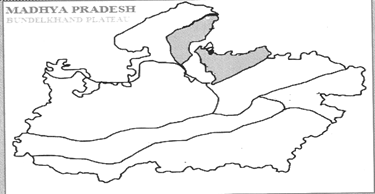
- This plateau is formed by the erosion of the old rocks (granite and gneiss). The problem of soil erosion is widespread in this plateau. Here Peneplain and Tor structures are found.
- Elevation:- Its average elevation is 150 m to 450 m from the mean sea level. Siddha Baba (1172 m) is the highest peak of this plateau.
- Vegetation:- The vegetation is like Savanna, with scattered Sagaun and Sal forests.Trees like Khair, Neem, Mahua, etc. are found here.
- Major Rivers:- Sindh, Betwa, Ken, Bagahin, Tons, Pahuj and Dhasan
- Districts:- It covers Chhatarpur, Panna, Tikamgarh, Niwari, Datia, Shivpuri and some parts of Guna districts.
- Climate:- It receives 75-100 cm of rainfall. The climate of this plateau is continental type.
- Soils:- Red and Black soils are found in this region.
- Crops:- Jowar, wheat and lentils are mainly grown in this area.
- Culture:-The famous tourist place of Madhya Pradesh i.e. Khajuraho is situated on this plateau. Sonagiri and Pitmbara Peeth in Datia are important tourist centres.
- Minerals :-Rock phosphate is the major mineral found here. The plateau consist of granite rocks of Archaean age.
- Industries:-Industrial development is negligible in this region. Cement and Bidi units are found in Chhatarpur and Datia districts.
Rewa-Panna Plateau
- The Rewa-Panna plateau is a triangle shaped plateau, region, formed by the Vindhyan rock system as a result of weathering and erosion of Archaean rocks. In the Rewa-Panna plateau topography, cracks and rifts have been found due to which it is also called Vindhyan Scarp land.
- This plateau is situated to the North-East of Bundelkhand plateau. It lies between 23°10? to 25°12? North latitude and 78°4' to 82°18? East longitude.
- On the south and south-eastern border of the Rewa-Panna plateau, the Bhander and Kaimur ranges of the Vindhyachal mountain range are located. The Narmada River flows to the south-west of the Rewa-Panna Plateau and the Son River parallel to the Kaimur Range in the northeast, that is, the south-west boundary of this plateau is defined by the Narmada River.
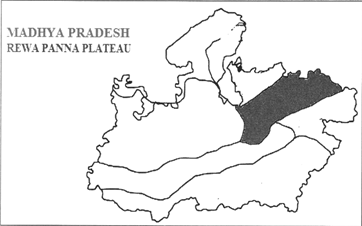
- The Kaimur Range acts as a water divide between the Yamuna and Son Basins and the Bhander Range between the Ganges and Narmada Basins. Bhander Range is in the southern part of the Vindhyanchal mountain range in Madhya Pradesh, which has a maximum elevation of 752 meters and Kaimur Range is in north-east of the Bhander Range, which has a maximum height of 686 meters.
- This region is also known as the Vindhyan Kagari (Verge) region.
- It covers an area of 31,954.8 sq km, which is 10.37% of the total area of Madhya Pradesh.
- Elevation:- Its average elevation is 300 to 450 m from the mean sea level. Chachai falls (130 meters) the highest fall in the state is also located in this region. Apart from this, there is a waterfall on odda river, and keoti waterfall on Mahana river.
- Rivers-Tons, Ken and Bihad are the major rivers of this region.
- Districts:- It covers Satna, Panna, Rewa and Damoh districts of Madhya Pradesh.
- The major rivers here are Ken, Sonar, Barna and Tons.
- Soils:- The red- yellow and laterite soils are found here. The problem of soil erosion is prevalent in this region.
- Vegetation; Bamboo, Tendu, Mango, Shisham, Sawai grass etc. are the major vegetation of the region.
- Climate:- It has a continental type of climate and receives 125 cm -127 cm of rainfall Maximum summer temperatures are 40°C to 42.5° C and in winters temperatures drop \[10{}^\circ C\text{ }to\text{ }l2{}^\circ C\].
- Crops:- Wheat is the major crop of this region but paddy is also sown towards the East of this plateau.
- Minerals:- Limestone, dolomite Gypsum and diamond are found in this region.
- Industries:- Rewa is famous for ceramic and Kattha industries, Satna are famous for Cement industry. It contributes around 8%-9% of India's total Cement production.
- Culture:- Region has a heritage of Baghel and Bundela kings. Chitrakoot, Bharhut Stupa (Satna) and Maihar are famous religious destinations. Govindgarh (Rewa) is famous for White Tigers.
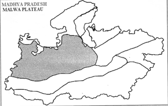
Malwa plateau
- The Central Western region of Madhya Pradesh is known as Malwa Plateau. If is composed of volcanic lava. It is formed by the basalt rocks of Deccan Trap.
- It lies between 20010? to 25°8' North latitude and 74°59' East longitude.
- It covers an area of 88,222 sq km which is 28.62% of the total area of Madhya Pradesh. It is largest plateau of the state.
- The Tropic of Cancer divides it into two equal parts.
- The average elevation lies between 350 m to 450 m. The highest peak of this plateau Sigar (881 m), Dhajari (810 m) and Janapav (854 m) peaks are also located in this plateau.
- Districts:-It covers Guna, Rajgarh, Raisen,Vidisha, Mandsaur, Jhabua and Dhar districts of Madhya Pradesh.
- The major rivers of this area are Chambal, Kshipra, Betwa, Sonar, Mahi, Parbati, et
- Climate:-The climate in this region is tropical monsoon type. It receives 125 cm of rainfall. That's why the region neither there is exuberant heat during summer nor there is extravagant cold during winter and most of the rainfall comes from the Arabian Sea branch of the Monsoon.
- Soil-Black soil is prominent in this region.
- Crops:-Wheat, Soybean, Cotton, Groundnut, Sugarcane, etc. are grown here.
- Vegetation-The natural vegetation is tropical dry forest, with scattered teak (Tectona grandis) forests. The main trees are Saugan, Sal and Tendu.
- Industries:-It is the major industrial region of Madhya Pradesh Cotton textile, automobiles, and pharmaceutical industries are prominent. Pithampur, Indore, Mandideep, Pilukhedi are main industrial centres.
- Culture:-The caves of Ujjain, Mandu, Sanchi, Vidisha and Bhimbetka are located in this plateau.
Geomorphic features of Malwa Plateau
The plateau is an extension of the Decean Traps, formed between 60 to 68 million years ago, at the end of the cretaceous period.
Relief- The average elevation of the Malwa plateau is 500 m. above sea level while most of this plateau has a height of 450 to 600 meters. The most important feature of the relief of this plateau is that generally the southern part of this plateau is relatively high while the northern side height reduced respectively. The Vindhyan ranges situated near the middle of the southern boundary is found at more than 800 meters in many places. The expansion of river valleys and high land with flat peaks on the Malwa plateau, having a sloping slope from south to north is also seen in the north-south direction.
- Deccan Traps- Malwa plateau is an extension of the Deccan traps. Deccan traps are one of the largest volcanic features on earth and it is spread all over the Malwa plateau. They consist of multiple layers of solidified flood basalt lava that together are more than 2000m thick. Deccan Traps began forming 66.25 million years ago, at the end of the cretaceous period.
- Sand Stone Hill- Erosion has carved the ancient lava flows into isolated mesas (an isolated flat topped hill with steep sides) found throughout the Malwa plateau, together with an occasional sandstone hill.
- Debris Slope- Debris slop largely found on Malwa plateau. A debris flow is a moving mass of loose mud, sand, soil, rock, water and air that travels down a slope under the influence of gravity. To be considered a debris flow, the moving material must be If and capable of 'flow' and at least 50% of the material must be sand size particles or larger.
- Pediment- Gently inclined rocky floors close to the mountains at their foot with or without a thin cover of debris are called pediments. They are largely found on Malwa plateau.
- Spheroidal Weathering of Malwa plateau- Spheroid weathering is a form of chemical weathering mat affects jointed bedrock and results in the formation of concentric or spherical layers of highly decayed rock within weathered bedrock that is known as Saprolite. When saprolite is exposed by physical erosion, these concentric layers peel off as concentric shells much like the layers of a peeled onion. Within saprolite, spheroidal weathering often creates rounded boulders.
The Vindhyanchal Range
- The Vindhyanchal Range is a complex, discontinuous chain of mountain ridges, hills range, high lands and plateau escarpments in west-central India.
- Vindhya Range today refers to the escarpment that runs north of and roughly parallel the North of Narmada River.
- The range extends up to Gujarat in the west, Uttar Pradesh and Bihar in the north and Chhattisgarh in the east.
- The mountains from the southern edge of the Malwa plateau and then divide into two branches-
- The northern branch that running north of the Son River.
- The Southern branch running between the upper reaches of the Son and Narmada rivers to meet near Amarkantak.
- The Vindhyan range at an elevation from 450 m to 1100 m gives rise to the m gives rise to the main southern tributaries of the Ganges-Yamuna system including the Chambal, Betwa, 1 and Tons rivers.
- The horizontal sandstone structure and the mountains tend to be flat topped and plateau like.
- The range is regarded as marking the border between Northern and Peninsular India.
1. Kaimur Range
- Eastern portion of the Vindhya Range
- Length: 483 km.
- Extended from the Jabalpur district of M.P. to Rohtas district of Bihar.
- Rivers: Son, Riband, Tons, Ken and Durgavati River are flow in this region.
- Major waterfalls- Purwa or Tons falls on the tons river (Rewa District)
- Chachai falls on the Beehar River
- Keoti on the Mahan River
- Odda falls on the Odda River
- Prehistoric rock paintings have been discovered in me Kaimur hills, Nawada and Jamui.
- Kaimur Range has metamorphic rock formations and up heaved rock strata.
2. Bhander Plateau
- It is a part of the Vindhya Range and is composed of fluvio-marine deposits of Cambrian age that have been uplifted and peneplained several times and are overlaid by dissected sandstone.
- It has an average elevation of 500 m and slopes from west to east.
- The swift flowing Tons and Son rivers have numerous falls and rapids along their courses and have cut deep gorges in the scarp lands.
- Forests of teak and catechu trees are mainly found here.
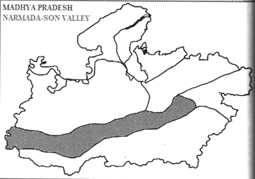
Narmada-Son Valley
- Land between the valleys of Narmada and Son in the East and West of Madhya Pradesh is known as the Narmada-Son Valley. Narmada Valley is the lowest the part of Madhya Pradesh. Narmada-Son valley is a narrow valley, which is situated between Vindhyanchal and Satpura mountain ranges. The Narmada-Son valley is bounded by the Bhander and Kaimur range of the Vindhyanchal mountain range in the north and the Satpura and Maikal ranges in the south and the Baghelkhand highlands in the east.
- It lies between 22°30' to 23945' North latitude and 74°30' to 81°30' East longitude.
- The Narmada-Son valley has been formed as a rift valley due to geological disturbances (displacement of crustal part) and it is the lowest landmass of Madhya Pradesh, which is 300 meters above mean sea level.
- The Narmada-Son valley is located in the middle of the Malwa plateau and Satpura range as the lowest landmass in Madhya Pradesh. The lowest part of the Narmada-Son valley extends to the state of Gujarat.
- This valley is composed of Deccan Trap, Vindhyan and Cuddapah rock system.
- It covers an area of 86,000 sq km which is 26% of the total area of Madhya Pradesh. It is India's largest rift valley. It touches both parts of Madhya Pradesh i.e. East and West. The average elevation of the region is 300 m.
- Districts: It covers Mandla, Jabalpur, Hoshangabad, Khandwa, Khargone, Barwani, Harda, Dhar and Dewas districts of Madhya Pradesh.
- The main rivers in this region are Narmada, Son,Tapti, Doodhi, Hiran, Sher, Hathni, Barna, and Shakkar etc.
- Soil: This part of the state is rich in Black and Red alluvial soil. The Son valley region is rich in Red soil.
- Crops: Groundnut, Wheat, Paddy, Cotton etc.
- Climate: It has a monsoonal type of climate and receives 125 cm of rainfall. Wheat, rice cotton, groundnut and soybean are grown here.
- Vegetation: Mahadeo and Satpura ranges have evergreen forests here. Sagaun, Tendu, and Semal are major species.
- Minerals: Narmada valley is rich in Minerals like limestone, fire clay, marble, manganese, etc.
- Industries: Cement and Glass based industries are located in Jabalpur.
- Culture: Amarkantak, Nemavar, Omkareshwar, and Maheshwar are major religious centres.
Geomorphology of narmada valley
The Narmada Valley is a Graben, (a layered block of the Earth's crust that dropped down relative to the blocks on either side due to ancient spreading of the Earth's crust). Two normal faults, known as the Narmada North fault and Narmada South fault, parallel to the river's course, and mark the boundary between the Narmada block and the Vindhya and Satpura blocks or Horsts which are relative to the Narmada Graben. The Narmada's watershed includes the northern slopes of the Satpuras, and the steep southern slope of the Vindhyas, but not the Vindhyan table land, the streams from which flow into the Ganges and Yamuna.
Relief of Narmada Valley
Narmada Valley region can be divided into five regions-
1. Plateau region of Maikal- The Plateau region of Maikal is located in the east of the Narmada Valley. This plateau act as water divides between Narmada and Mahanadi with an average elevation of 600 to 900 meters. The Narmada River is originated from the Amarkantak site of this plateau.
2. Mountainous region of Vindhyan- In the northern part of Narmada valley region, the mountainous part of Vindhyan is extended from west to east, with a steep slope towards the Narmada Valley. The altitude of this mountainous region is 610m above the sea level. Some parts of the plains surrounded by highlands are also found in this mountainous region.
3. Satpura Range- In the southern part of the Narmada valley region, the Satpura Range is expanding from West to East. Many small streams originate from this region and merged into Narmada River. The valleys of these streams are narrow which widens towards the Narmada Valley in the north.
4. Intermediate Plain- The intermediate plain in the Narmada valley region extended from Hiran River in the east to Khargone district in the west, in which the Narmada River flows along its valley. The width of this ground is 40 to 120km. Generally it is a fertile plain but small Hills also seen on it. The average elevation of this plain is between 250 to 300m above sea level.
5. Dhar Highland- Dhar highland is in north-western part of Narmada valley. It if forested hilly region which has been cut by rivers in several parts.
Other landforms
The Narmada Valley mainly consists of rocks of the Deccan Trap. After erosion of Deccan Trap, the Valleys of Vindhyan rocks also been exposed. In some parts of Narmada valley, structures that made by depositional of rivers and estuaries are found, which are known as Bagh series. Some new rock deposits compare to Bagh Series also found in Narmada valley, which is called Lameta Series. In Lameta Series fossils of Dinosaur also found. Major rocks found in Narmada valley are- Sand stone. Clay stone Grit and Conglomerate.
Due to its erosional tendency Narmada river makes caves in it course and forms unique Landforms easily visible at Mandhata caves and other various caves in Jabalpur.
Narmada River makes some beautiful falls along its way- Dhuandhar, Dugdhdhara, Kapil dhara, Mandhar and Dardi.
Narmada River has carved me soft marble rocks and made several gorges, creating a beautiful gorge of about 8 km in Bhedaghat Earlier, the Gorge was narrow in size and hence monkeys could cross over from one side to another. This gave the gorge its local name- Bandar kudni. Mandhata and Mukarta are other major gorges.
Narmada valley is a Rift valley. In most part of it the banks stand on both sides as a clif. This rift valley marks the boundary between the Vindhyan and Satpura Block Mountains
This is a major feature of Narmada River. Unlike the other rivers of peninsula the Narmada builds estuary in place of Delta. An estuary is a partially enclosed coastal body of brackish water with one or more rivers or streams flowing into it and with a free connection to the open sea, from time to time the tide flows away the sediments present in the coastal water due to which delta cannot be formed.
Satpura and Maikal Ranges
- Satpura and Maikal ranges are situated on Southern part of Madhya Pradesh. The Satpura Range lies between the rift valleys of Narmada and Tapti as Rajpipla hill, Mahadev hill and Maikal range from west to east. In the east it extends to the Chota Nagpur Plateau.
- This mountain range is a block mountain mainly composed of granite and basalt rocks. The Deccan Trap and Dharwar group of Rocks Constitutes this region.
- The Narmada and Son rivers originate from the Amarkantak plateau in the Maikal range of the Satpura range.
- These ranges lie between \[\mathbf{21}{}^\circ \mathbf{30}'\mathbf{to23}{}^\circ \mathbf{30}\mathbf{to23}{}^\circ \mathbf{30}'\]North latitude and \[\mathbf{74}{}^\circ \mathbf{30}'\mathbf{to}\text{ }\mathbf{81}{}^\circ \mathbf{30}\] East longitude.
- This Satpura range is flanked by Narmada in me North and Tapti in the South. It covers an area of 900 sq km.
- The Satpura range act as a dividing line between the catchment areas of the Narmada and the Mahanadi. This range extends westwards to Bhedaghat and divides the catchment area of the Narmada in the southwest and the Banjar river in the west, and the Hallon river in the east and northeast. There are several branches originating from the main Maikal Range and from Bhaisan ghat towards the north, which divides the water moving towards the Hallon River into several streams, such as Fen, Gaurduni, Kashmiri and Gondla.
Satpura -Maikal Range acts as a floodgate between the Narmada-Son Valley and the Deccan Plateau in Madhya Pradesh. The Tapti and Wainganaga originated from the southern slope of the Satpura-Maikal Range and the Son, Narmada and Johila rivers originate from the north-eastern slope, which are the most water-harvesting rivers in the state.
- Sub- Divisions: This region can be further sub-divided into three ranges:
- Rajpipla Range- It is the Western part of the Satpura and Maikal range. It is very deformed and its topography is very uneven. It consists of Burhanpur pass Akhrani, Barwani, Asirgarh ranges are also the part of Rajpipla mountain ranges.
- Central Range- Falls in the East of Rajpipla ranges. It include different ranges. Gawilgarh range, Mahadeo range etc. Dhoopgarh (1350 m) in Mahadeo range is the highest peak in Madhya Pradesh located in this region.
- Maikal Range- It makes the Eastern boundary of this range. It is a plateau with dense forest and cool climate. It is composed of Deccan Trap and has a thick covering of Laterite soils. Amarkantak Mountain is a part of Maikal ranges. Rivers like Narmada, Son and Johila are originated from the Amarkantak plateau (Maikal Range) located in the eastern part of the Satpura Maikal Range in Madhya Pradesh. Due to the origin of many rivers from the Maikal range, it is called a watershed.
- Elevation: The maximum elevation of these ranges is 1200-1350 m. being very rocky and sloppy in nature, the transportation is not good in this region.
- Districts: Chhindwara, Burhanpur, Khandwa, Seoni, Betui, Mandla, Balaghat, Jhabua etc. are the major towns of this region.
- Climate: It has a monsoonal type of climate and receives 125-150 cm of rainfall. Panchmari gets highest Rainfall during monsoon located in this Region.
- Vegetation: This region is rich in forests and therefore a large number of populations depend upon forest resources. Sal, Sagon, Palash, and Tendu leaves are major forest produce.
- Rivers: The main rivers of this region are Narmada, Tapti, Wainganga and Tawa.
- Soils: Medium black and sandy soils are found here.
- Crops: Agriculture is done in the plain areas. Jowar is the main crop which is grown here. Other crops grown in this range are wheat, rice, cotton, etc.
- Minerals: This region is rich in Manganese, coal, copper, bauxite and iron etc.
- Industry: Nepanagar, Betwal and Chhindwara are major industrial centres of this region.
- Culture: Pachmarhi, Muktagiri and Bawangaja are major tourist attraction.
- Tribes: Bhil, Gond, Korku and Bhariatnbss reside here.
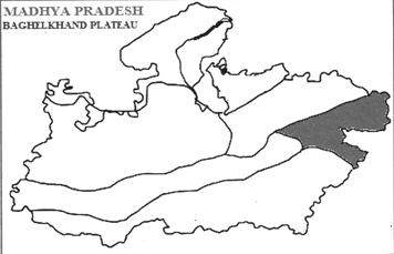
Eastern or Baghelkhand Plateau Region
- Baghelkhand plateau is located in the northeast of Madhya Pradesh as the eastern part of the southern peninsular plateau. Uttar Pradesh is in the north of the Baghelkhand plateau, Bihar in the east and the state of Chhattisgarh is in the south-east and the Son River in the south makes its boundaries.
- The total area of the Baghelkhand plateau is 1,40,000 sq km, which covers 25,000 sq km in Madhya Pradesh and it is 7% of the total area of Madhya Pradesh. The Baghelkhand plateau is the smallest plateau in Madhya Pradesh in terms of area.
- The major rock system of the region includes Vindhyan and Gondwana groups. Son valley region is covered with the Vindhyan rock group and the southern portion of the plateau is covered with the Dharwar rock group.
- It lies between \[\mathbf{23}{}^\circ \mathbf{40}'\text{ }\mathbf{to24}{}^\circ \mathbf{35}'\]North latitude and \[\mathbf{80}{}^\circ \mathbf{5}'\text{ }\mathbf{to82}{}^\circ \mathbf{47}'\]East longitude.
- Districts: Rewa, Satna, Shahdol, Umaria, Sidhi, Singrauli and Anuppur districts are the part of this region. Tropic of Cancer passes through the middle of this region.
- Major Rivers: Son, Riband, Vanas and Johila rivers flow in this region.
- Climate: The climate here is of monsoon type and receives 75- 125 cm of rainfall. The region has mild summer and mild winters.
- Soils: Different types of soils like black, red and yellow soils are found here.
- Crops: Rice, linseed, jowar and other coarse grains are grown here.
- Minerals: Coal, Bauxite, limestone etc. are found here in abundance. Major coal beds of Madhya Pradesh are also found in this region. The second largest coal field of the state is located in Singrauli district under the Baghelkhand plateau of Madhya Pradesh. Apart from this, Sohagpur, Korar and Johila coalfields in Shahdol and Umaria districts are also located in Baghelkhand plateau.
- Industry: Arnlai paper mill, Singrauli power generation units.
- Culture: Bagheli and Chhattisgarhi dialect is used in the region. Baiga, Koland Birhor tribes reside in the region.
Physiographic regions of Madhya Pradesh
|
Region
|
Area (sq km)
|
Districts
|
Formation
|
Rivers
|
|
Central India
Plateau
|
32,896
|
Bhind, Morena, Gwalior, Shivpuri, Guna, Mandsaur
|
Vindhyan rock group with Deccan Trap
|
Chambal, Kalisindh, Parvati
|
|
Bundelkhand
Plateau
|
23,733
|
Chhatarpur, Panna, Tikamgarh, Datia, Shivpuri, Guna, Sagar, Niwari
|
Erosion of granite and gneiss rocks
|
Betwa,Ken, Dhasan, Sindh
|
|
Rewa-Panna Plateau
|
31,954.8
|
Satna, Panna, Rewa, Damoh
|
Cuddapah rocks of Deccan Trap
|
Tons, Ken, Bihad
|
|
Malwa Plateau
|
88,222
|
Guna, Rajgarh, Raisen, Dewas, Sagar, Shajapur Ujjain, Ratlam, Mandsaur, Jhabua,etc.
|
Basalt rocks of Deccan Trap
|
Shipra, Betwa, Parbati, Chambal, kalisindh
|
|
Narmada-Son Valley
|
86,600
|
Jabalpur, Narsinghpur, Hoshangabad, Raisen
|
Deccan Trap, Dharwar, Vindhya and Cuddapah rocks
|
Narmada, Son, Tawa, Sher, hathani, Shakkar, Johila
|
|
Satpura- Maikal Range
|
900
|
Balaghat, Seoni, Chhindwara, Betul, Khandwa, Khargone
|
Deccan Trap, Dharwar rocks
|
Tapti, Wainganga, Tawa
|
|
Beghelkhand Plateau
|
25000
|
Shahdol, Umaria, Singrauli, Dindori
|
Gondwana, Vindhya rocks
|
Son, Rihand, Johila
|
Rivers
- Rivers- A large natural stream of water flowing in a channel to the sea, a lake or another river is called River.
- River Basin- A river basin is the portion of land drained by a river and its tributaries.
- Drainage Basin- Drainage system, also known as river system, is the pattern formed by the streams, rivers and lakes in a particular drainage Basin. General Studies Paper-l
- Water Divide-An elevated area such as mountain or an upland that separates two drainage basins is known as water divide.
- Watershed- A water describes an area of land that contains a common set of streams and rivers that all drain into a single larger body of water, such as a larger river, a lake or an ocean.
Rivers of Madhya Pradesh
Madhya Pradesh is rich in water resources. The northern part of the state drains largely into the Ganga basin and the southern part into the Godavari and Tapti (Tapi) system. The Narmada, Tapi and Mahi rivers flow from east to west. The Vindhyas form the southern boundary of the Ganga Basin, with the western part of the basin draining into me Yamuna and the eastern part directly into the Ganga itself. All the rivers, which drain into the Ganga basin flow from south to north, with the Chambal, Shipra, Kali Sindh, Parbati, Kuno, Sind, Betwa, Dhasan and Ken rivers being the main tributaries of the Yamuna, joining the Ganga. While Tons and Son which originate in the state join directly the Ganga. The Son is of great significance in that it is the largest tributary going into the Ganga from the south bank and arising out of the hills of Madhya Pradesh rather than from the Himalayas. Most of the peninsular rivers originated from the mountain ranges of Maikal, Vindhyan, and Satpura, that is why Madhya Pradesh also known as "Maika of rivers" In the drainage system of Madhya Pradesh, Vindhya and Satpura mountain ranges act as water divide.
Division of Drainage system of Madhya Pradesh- Madhya Pradesh Drainage system is divided into six major parts
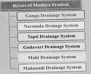
- The Ganges drainage system is the largest among these. Most of the state's water flows through this system. Apart from these, Mahi Basin and some part of Mahanadi basin also comes in state. The slope of the central and northern part of the state is towards the northeast; hence the direction of all the rivers of this region follows it.
- Satpura-Maikal Range and Vindhyanchal Range and Kagari regions act as major water dividers in the state. Rivers originating from the south of Satpura Mountain flows southward, among these, Wainganga and its tributaries are prominent.
- The Narmada and the Tapti rivers flow west in the fault basins. The drainage system of the Narmada River is confined between the Satpura and Vindhyachal ranges.
- Rivers originate from the Maikal plateau flows in all four directions. Vindhyachal- Bhander-Kaimur ranges also act as water divide. Chambal, kali sindh, parvati, Betwa are the major rivers flowing north-east. Due to the Kaimur verge, the Son and its tributaries Gopad and Banas flow south to north-east direction.
- Due to the variation of the surface, almost all types of drainage system are found here. The rivers Narmada and Tapti flow into the faulted valley and fall into the Arabian Sea in the west. These rivers provide an example of Consequent drainage pattern. From the Amarkantak plateau Narmada, Son originates from the western and northern respectively. Tapti and Weinganga are the major rivers originating from Betui plateau.
- The Chambal River exhibits a superimposed model.
- Most of the rivers in the state present a Dendritic pattern. The major rivers flowing in such a pattern are the tributaries of the Son, Gopad, Banas and Narmada (most rivers of the Malwa region).
- Rectangular Drainage is found somewhere along the route of the river Son. Also seen in the area of Vindhyan rocks.
Ganga River Basin
The water of the wide northern part of the state reaches the Ganges through various rivers, which carry it to the Bay of Bengal. This drainage area is divided into three sub-drainage zones. The main rivers of these areas are-
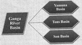
Yamuna Drainage Basin
The main rivers of this drainage are Chambal, Ken, Dhasan, Betwa, Kunwari, Sindh and Jamani.
- Chambal
- It is the largest river in northern and western Madhya Pradesh.
- The river originates from the Sigar peak (843 m), situated on the Vindhyanchal range near Mhow in Indore district and flows north and north-east into Rajasthan.
- From here it once again joins the Yamuna River in Etawah (U.P.), forming the boundary of Sheopur, Morena and Bhind districts of northern Madhya Pradesh. Where it meets Yamuna, there are also four other river, which is why it is called Panchanad.
- In this way it forms a border between Madhya Pradesh and Rajasthan and Madhya Pradesh and Uttar Pradesh for a considerable distance.
- Its total length is 965 km. Its runoff area is 43200 Sq km.
- The Chambal river forms deep ravines (Ravines are a type of fluvial erosional feature and are formed as a result of constant vertical erosion by streams and rivers flowing over semi-arid and arid regions) in Morena and Bhind districts.
- Badland topography is a major feature of the Chambal valley is characterized by an undulating floodplain, gullies and ravines.
- The major tributaries of Chambal River are kshipra, kali Sindh, Betwa, Parvati, Kunwari and Banas.
- Gandhi Sagar Dam (Madhya Pradesh-Rajasthan joint venture), Ranapratap Sagar and Kota Dam (Rajastha) have been built on the Chambal river , in which hydropower is also prepared besides irrigation.
- Kshipra
- It is a sacred river. Its ancient name is Avanti.
- It originates near Indore and flows northwards. Its total length is about 195 km and Gambhir is its major tributaries.
- Ujjain city is situated on the banks of river Kshipra. Finally Kshipra River merges into Chambal River near Mandsaur district.
Narmada Shipra Sihastha Link Pariwiana
- A project linking Shipra river to Narmada was commenced in 2012 and completed in 2015 successfully. The project lifts water from the Narmada River using electricity, and then transports it to the source of Kshipra river through pipes. The link project is the first phase of Rs 8000-crore Narmada-Malwa Link project. Under the project, Narmada would be connected to Kshipra, Gambhir, Kalisindh and Parbati rivers.
- Sindh
- The Sindh originates on the Malwa Plateau in Vidisha district, and flows north- northeast through the districts of, Ashoknagar, Shivpuri, Datia, Gwalior in Madhya Pradesh to join the Yamuna River in Jalaun district, Uttar Pradesh.
- Its total length 470 km, out of which 461 km is in Madhya Pradesh.
- Its tributaries are Pahuji, Kuwari, Mahur and Parvati.
- Betwa
- Its ancient name is Vetravati.
- It rises in the Vindhya Range just north of Hoshangabad and flows in northeast direction and enters Uttar Pradesh via Bhopal and Vidisha districts.
- Near Hamirpur, it joins the Yamuna River.
- The Betwa River carries most of the water of eastern Malwa region.
- Its total length is 480 Km, out of which 380 Km is in Madhya Pradesh.
- Bina, Ken and Dhasan are the main tributaries of Betwa River.
- The Betwa River is also known as Ganga of Madhya Pradesh and the lifeline of Bundelkhand. It forms the natural boundary of Madhya Pradesh and Uttar Pradesh.
- Dhassan
- It is a tributary of Betwa River.
- It originates from the Begumganj tehsil of Raisen district and flows towards the northeast.
- Its total length is 365 km, out of which 240 km in Madhya Pradesh, 54 Km on the border of Madhya Pradesh and Uttar Pradesh and 71 km is in Uttar Pradesh.
- It drains the water of Raisen and Sagar districts and takes them to Betwa. The Lehchura dam on Dhasan River is built near harpalpur.
- Ken
- The Ken River originates near the village Ahirgawan on the north-west slope of Bhander Range in Kami district and travels a distance of 427 km, before merging with the Yamuna at Chilla village, district Banda in Uttar Pradesh.
- Its total length is 427 km, out of 292 Km is in Madhya Pradesh, 51 Km on the border of Madhya Pradesh and Uttar Pradesh and 84 Km is in Uttar Pradesh.
- Raneh Falls and Ken Gharial Sanctuary are notable tourist places.
- Sonar, Bevus, Urmil, Baghneri and Bana are its major tributaries.
- Tons
- The Tons River originates from the reservoir called Tamashakund in the kaimur Range and flows to the Rewa Plateau towards the northeast.
- Flowing towards the northeast, this cuts the Panna hill and creates many famous waterfalls, of which Chachai waterfall is prominent.
- Its length is 264 km and it joins the river Ganges near Allahabad. It is also known as Tamasa. Its major tributary is Belan.
- Son
- The Son originates near Amarkantak in Anuppur district, just east of the headwater of the Narmada River, and flows north-northwest through Shahdol district before turning sharply eastward where it encounters the southwest-northeast-Kaimur Range
- The Johila is the main tributary found in this part. Its northern coast is narrower and parallel to the kaimur verge, here it seems to be the imposing valley.
- Most of the water in the Baghelkhand plateau (Anuppur, Shahdol, Umaria, Sidhi and Singrauli districts) flows through the sons and its tributaries. Beyond the sidhi distrit of Madhya Pradesh, it flows into the states of Uttar Pradesh, Jharkhand and Bihar an joins the Ganges River near Patna.
- On the right bank major tributaries are Gopad, Banas and Riband. Its total length 780 km. Its length in Madhya Pradesh is 509 km.
- Sindh
- It is the main river in the western part of Bundelkhand, which joins the Yamuna near Janmagar in Uttar Pradesh.
- It collects the water from the Vidisha, Guna and Shivpuri district. Among its tributaries, paravati and pahuj are prominent.
Narmada River system
- The Narmada River, also called the Reva and previously also known as Narbada.
- It is also known as "Life Line of Madhya Pradesh and Gujarat" for its huge contribution to the state of Madhya Pradesh and Gujarat in many ways.
- Narmada rises from the Narmada Kund (1057 m) in Amarkantak Plateau in Anuppur district Madhya Pradesh.
- It is the fifth largest river in the country. It has been considered a divider of North India and South India. It is the largest river flowing from east to west in peninsular India.
- Kapildhara and Dugdhdhara are the major waterfalls near Narmada kund.
- Near Jabalpur it enters into the plains and turns towards south. In Jabalpur it forms the famous 'Dhuadhar' waterfall and flows in a narrow gorge. From here it enters the Jabalpur-Haveli plains.
- It is one of the few rivers in India that flows in a rift valley, flowing west between the Satpura and Vindhya ranges it enters the Hoshangabad plain. To the west of this plain, it passes through a hill made of ancient rocks where Vindhyan cuts the rock and creates the 'Mandhata' gorge. After crossing this gorge, Narmada enters the Dhar high ground flowing through the plains of Mandleshwar. From there, this river enters into 120 Km long Mukta gorge. Only then does this river enter the Gujarat border and finally falls into the Arabian Sea.
- Among its tributaries coming from the south are Sher, Sakkar, dudhi, tawa and ganjan. The main tributaries from the north are hiran, barna, choral, karam.
- The drainage pattern in the entire basin is of the Dendritic pattern. 90 percent of me entire Narmada Basin is in Madhya Pradesh and its length in the state is 1077 Km.
The Tapti river system
- It is the second major river in the state after Narmada, flowing towards the Arabian Sea.
- It originates from Multai in Betui district and flows westward.
- From the origin to the Burhanpur, the Tapti River flows through the hilly part.
- It has built many caves along its course in Satpura range.
- Turning south-west form the boundary of Bhainsdehi and enters Maharashtra through the middle of Burhanpur. The river valley has widened in Burhanpur, on which parallel hills are located on both sides.
- It discharges its water into the Gulf of khambat in the Arabian Sea.
- The Tapti River flows parallel to the Narmada River to me north.
- Its total runoff area is 65145 Sq Km. Out of which only 9804 Sq km in Madhya Pradesh, 51504 Sq km in Maharashtra and 3837 Sq km comes in Gujarat. The total length of this river is 724 km.
- Poorna is its tributary of Madhya Pradesh region,
- Betui, Nepanagar and Burhanpur are situated on the banks of this river.
Godavari Drainage basin
The Godavari river system can be divided into five sub systems based on its main tributaries:-
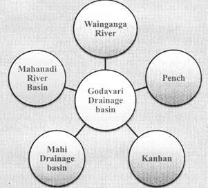
- Wainganga River
- The Wainganga River is the most prominent river of this system originating from state.
- The Wainganga River is originating from the Mahadeo Hills in Mundara near village Gopalganj, district Seoni.
- It is a key tributary of the Godavari.
- Its flow area in the state is in Seoni and Balaghat districts. It flows southeast enters Bhandara district of Maharashtra.
- After the merger of the Wardha River, it known as Pranhita which is further merged in Godavari. The Wainganga River forms a flood plain and has many meanders Bagh, Bawanthadi, Pench, Kanha are prominent among its tributaries.
- Pench
- Pench River originates from the Junnardev hill in Chhindwara district and passes through the Pench National Park.
- It passes through the seoni and chhindwara district. It merges into Kanhan River near Kamthi, district Nagpur.
- Kanhan
- Kanhan River originates from the hills of Pachmarhi near Damua, flows southeast and meet Wainganga in Nagpur district.
- It is the largest tributary of Wainganga River. It has a total length of 275 km. Most part of the Bagh, Bawanfhadi and Thanwar river systems are located in Balaghat district.
- Mahi drainage basin
- Mahi is one of the three rivers of peninsular India that flows westwards. It originates from Minda village near Sardarpur in Dhar district and flows north and north-west enters Rajasthan and further turns south-west and falls into the Gulf of Khambhat, passing through the state of Gujarat.
- Its total runoffarea is 38699 Sq km out of which 7188 Sq km is located in the state.
- Mahanadi river basin
- After the formation of Chhattisgarh State, the major portion of Mahanadi basin now lies in Chhattisgarh. Presently, only 154 km2 basin area of Hasdeo River in district Anuppur lies in Madhya Pradesh.
River Basins of Madhya Pradesh
|
S.No.
|
River
Basin
|
Key rivers (length within the state in Km)
|
Catchment in the state
(sq Km)
|
Key tributaries
|
|
1.
|
Ganga
|
Son (500 Km)
|
47849
|
Mahanadi, Katni, kawal, Johila, Gopad, Bana, Kanhar, Rehar
|
|
2.
|
|
Tamas (Tons) (238 Km)
|
11974
|
Simarbarh, Satna, Bihar, belan, sonekar
|
|
3.
|
Yamuna
|
Chambal (965 Km)
|
59940
|
Kalisindh, Parvati, Kshipra, Khan, Kuno, Seop
|
|
4.
|
|
Sindh (450 Km)
|
59940
|
Kunwari, Mahuar, Pahuj
|
|
5.
|
|
Betwa (216 Km)
|
19365
|
Kaliasot, Halali, Baah, Bina, Dhasan, Jamni
|
|
6.
|
|
Ken (360 Km)
|
24785
|
Sonar, Bewar, bearma
|
|
7.
|
|
Baghain
|
-
|
-
|
|
8.
|
Narmada
|
Narmada (1077 Km)
|
85930
|
Tawa, Barna, Dudhi, shakkar, Hathani, Tendubi, Hiran
|
|
9.
|
Tapti
|
Tapti (332 Km)
|
9800
|
Ambharo, Mano, Puna, Kanair, Kanha, sukta
|
|
10.
|
Godawari
|
Wainganga (272 Km)
|
|
Pench, Kanhan, Bagh
|
|
11.
|
Mahi
|
Mahi (183 Km)
|
|
Anas, Khairya, Bageri, Jammar
|
Summary
Geographical Divisions of Madhya Pradesh
On the basis of surface features, there are three geographical divisions in the state.
These are as follows:
- Central Highlands
- Satpura and Maikal Ranges
- Eastern or Baghelkhand Plateau Region
Central Highlands
Central highlands of Madhya Pradesh is a triangular elevated land from West to East which is surrounded by Narmada-Son valley in the South, Kaimur range in the East and Aravalli range in the West. These highlands are further classified into five regions:
- Central India Plateau
- Bundelkhand Plateau
- Rewa-Panna Plateau
- Malwa Plateau
- Narmada-Son Valley
Central India Plateau
- Central Indian Plateau (Madhya Bharat plateau) comprises the northern part of the Central Highlands. It covers most of the North-western Madhya Pradesh. It covers an area of 32,896 sq km which is 10.68% sq of the state's total area.
- It lies between 24°10' to 26°48' North latitude and 74°50' to 79°18' East longitude.
- It is bounded by the Upper ?Ganges plain to the North, the Budelkhand upland to the East, the Malwa plateau to the South and the East Rajasthan uplands to the west. The Bundi and Karauli Hills form its Western boundary. The area is marked by deep ravines of Chambal River.
Bundelkhand Plateau
- The Northern area of Central Highlands is known as the Bundelkhand plateau. Bundelkhand lies in the east of the plateau of Malwa and the Central India Plateau in the North- West. This plateau with volcanic origin is a part of central Madhya Pradesh and south eastern Rajasthan.
- The Bundelkhand plateau is formed in pre-Cambrian epoch in the form of Bundelkhand gneisses,
- It lies between 2406' to 26022' North latitude and 77051' to 80020' East longitude. This plateau is situated to the East of the Central India plateau and it is bounded by Rewa-Panna plateau on North-East.
Rewa-Panna Plateau
- The Rewa - Panna plateau is a triangle shaped plateau, region, formed by the Vindhyan rock system as a resul of weathering and erosion of Archaean rocks. In the Rewa-Panna plateau topography, cracks and rifts have been found due to which it is also called Vindhyan Scarp land.
- This plateau is situated to the North-East of Bundelkhand plateau. It lies between 23010' to 25012' North latitude and 7804'to 82018'East longitude.
Malwa Plateau
- The Central Western region of Madhya Pradesh is known as Malwa Plateau. It is composed of volcanic lava. It is formed by the basalt rocks of Deccan Trap.
- The Tropic of Cancer divides it into two equal parts.
- It lies between 20010' to 2508' North latitude and 74059' East longitude.
- It covers an area of 88,222 sq km which is 28.62% of the total area of Madhya Pradesh.
Narmada-Son Valley
- Land in between the valleys of Narmada and Son in the East and West of Madhya Pradesh is known as the Narmada-Son Valley. Narmada-Son Valley is lowest part of Madhya Pradesh. Narmada-Son valley is a narrow valley, which is situated between Vindhyachal and Satpura mountain ranges. The Narmada- Son valley is bounded by the Bhander and Kaimur range of the Vindhyanchal mountain range in the north and the Satpura and Maikal ranges in the south and the Baghelkhand highlands in the east.
- It lies between 22°30' to 23°45' North latitude and 74°30' to 81°30' East longitude.
Vindhya Range
- Length-1086 km
- Elevation- 450 to 110 m
- Broken range of hills forming the southern as carpment of the central upland of India.
- Kaimur and Bhander are major Hills.
- Chambal, Betwa, ken and tons major river.
- Makred the border between northern and peninsular India.
Satpura and Maikal Ranges
- Satpura and Maikal ranges are situated on Southern part of Madhya Pradesh. The Satpura Range lies between the rift valleys of Narmada and Tapti as Rajpipla hill, Mahadev hill and Maikal range from west to east. In the east it extends to the Chhota Nagpur Plateau.
- This mountain range is a block mountain mainly composed of granite and basalt rocks. Deccan trap and a Dharwar rock group constitute this region.
- These ranges lie between 21°30' to 23°30' to 23°30' North latitude and 74°30' to 81°30' East longitude
Eastern or Baghelkhand Plateau
- Baghelkhand plateau is located in the northeast of Madhya Pradesh as the eastern part of the southern peninsular plateau. Uttar Pradesh is in the north of the Baghelkhand plateau, Bihar in the east and the state of Chhattisgarh is in the south-east and the Son River in the south makes its boundaries.
- The total area of the Baghelkhand plateau is 1,40,000 sq km, which covers 25,000 sq km in Madhya Pradesh and it is 7 percent of the total area of Madhya Pradesh.
- It lies between 23°40' to 24°35' North latitude and 80°5' to 82°47' East longitude.
- Districts: Rewa, Satna, Shahdol, Umaria, Sidhi, Singrauli and Anuppur.
Rivers of Madhya Pradesh
Division of Drainage system of Madhya Pradesh
Madhya Pradesh Drainage system is divided into six major parts-
- Ganga drainage system
- Narmada drainage system
- Tapti drainage system
- Godavari drainage system
- Mahi drainage system
- Mahanadi drainage system
Ganga River Basin
The water of the wide northern part of the state reaches the Ganges through various rivers, which carry it to the Bay of Bengal. This drainage area is divided into three sub- drainage zones. The main rivers of these areas are-
- Yamuna Basin
- Son Basin.
- Tons Basin
Yamuna Drainage Basin
The main rivers of this drainage are Chambal, Ken, Dhasan, Betwa, Kunwari, Sindh and Jamani
Narmada River system
- The Narmada River, also called the Reva and previously also known as Narbada.
- It is also known as "Life Line of Madhya Pradesh and Gujarat" for its huge contribution to the state of Madhya Pradesh and Gujarat in many ways.
The Tapti river system
- It is the second major river in the state after Narmada, flowing towards the Arabian Sea.
- It originates from Multai in Betui district and flows westward.
Godavari Drainage basin
The Godavari river system can be divided into five sub systems based on its main tributaries:-
- Wainganga
- Bagh
- Bawanthadi
- Pench
- Kanhan
Probable questions
1. Very Short question
- Madhya Pradesh is divided into how many geographic regions?
- Which are the major tourist destinations in Bundelkhand region?
- Which are the major Minerals found in the Satpura-Maikal region?
- Write a short note on Dhupgarh.
- Which are the major rivers in the Central Indian plateau?
- Which are the major in industrial centres in the Rewa-Panna plateau?
- Which is the place of origin of river Son? (MPPSC-2014)
- Narmada River forms which waterfall in Jabalpur. (MPPSC-2015)
- Name two rivers of Madhya Pradesh which flow through rift valley and form estuaries. (MPPSC-2015)
- Which is the place of origin of river Tons. (MPPSC-2016)
- Name the origin place of Tapi River. (MPPSC-2018)
- Explain the Geographical location of "The Central Highland." (MPPSC 2014)
- Location of Bundelkhand Plateau of Madhya Pradesh. (MPPSC 2016)
- Vindhyachal mountain range comprises of which hills? (MPPSC 2018)
2. Short Questions
- Explain the geographic features of Malwa plateau.
- Madhya Pradesh is divided into how many geographic regions? Explain the geographic features of Rewa-Panna plateau.
- Explain the geographic characteristics of Satpura range.
- Explain the Physiography of Baghelkhand region. (MPPSC2014)
- Discuss economic significance of Malwa plateau Region. (MPPSC2015)
- Write a note on the geographical characteristics of Vindhyachal and Baghelkhand Plateau. (MPPSC 2017)
3. Long questions
- Explain the Physiography of central highlands in detail.
- Give a detailed account of the Physiography of Bundelkhand and Malwa plateau.
- Describe the drainage system of Madhya Pradesh. (MPPSC 2017)
- Divide Madhya Pradesh into Physical divisions and present their detailed account. (MPPSC 2017)


