Current Affairs MP State Exams

  Chapter - 1 Madhya Pradesh: Introduction   Madhya Pradesh is a state of vivid culture, historical places, hill stations, and rich wildlife experiences. Madhya Pradesh which is also known as Hriday Pradesh lies in the middle of [India and shares its borders with five neighboring states. Spread over an area of 3,08,252 kilometer square covering 52 districts, MP has varied topographic and climatic characteristics. The state is completely landlocked. The state covers wide area of Indian plateau regions. The state is endowed with rich natural resources and fertile agro climatic conditions.     Madhya Pradesh forms part of peninsular plateau of India, lying in north central part. Most of the sate lies on the table land of Central India, which is a part of the oldest Gondwana Land. The natural boundary of Madhya Pradesh is determined by the Chambal River in the north and plains of Ganga-Yamuna, in South. In north-west Aravalli mountain range. In north-east Son River, and in South-East Amarkantak Plateau.   Geographical expansion of Madhya Parades is in between the latitude of \[21.6{}^\circ N-26.30{}^\circ N\] and longitude of \[{{74}^{o}}9'E-{{82}^{o}}{{48}^{}}E.\]  
  • Tropic of Cancer (\[23{}^\circ 30'\]North latitude) divides Madhya Pradesh into two equal parts, passing through 14 districts of the state- Ratlam, Ujjain, Agar-Malwa, Rajgarh, Sehore, Bhopal, Vidisha, Raisen, Sagar, Damoh, Katni, Jabalpur, Umaria and Shahdol.
   
  • Ratlam District is situated in the north of Tropic of Cancer. Bhopal is the only division through which the Tropic of Cancer passes through all the districts (Bhopal Sehore, Vidisha, Rajgarh, Raisen).
  • Agar-Malwa was declared a district by separating it from Shajapur district on August 16, 2013, because of the separation of the district from Shajapur, now the Tropic of Cancer passes through Agar-Malwa district instead of Shajapur.
  •  Indian Standard Time (IST) Line or India's Meridian (\[82{}^\circ 30'\]East longitude) passes through Singrauli district under Rewa division of Madhya Pradesh.
  • Singrauli district is situated between \[23{}^\circ 49\]' northern latitudes and 24°42' north latitudes and \[81{}^\circ 18'\] east longitudes and \[82{}^\circ 48'\] east longitudes. Before the formation of Singrauli district in Year 2008, the Indian standard time line passed through Sidhi district.
  • The eastern and western border of Madhya Pradesh there is a difference of 34 minutes (8.4) hence sunrise half an hour earlier than the Singrauli in the most eastern district than in Alirajpur is the most western district of Madhya Pradesh. Alirajpur is located between\[22{}^\circ 18'19'\]northern latitude and \[74{}^\circ 21'9'\]east longitude and Singrauli is located \[23{}^\circ 49'\] north latitude to \[24{}^\circ 42'\]north latitude and \[81{}^\circ 18'\]east longitudes to \[82{}^\circ 48'\]east longitudes.
  Political boundaries of Madhya Pradesh   more...

  Chapter-2 Geology   Geology is an earth science concerned with the solid Earth, the rocks of which it is composed, and the processes by which they change over time. Geology describes the structure of the Earth on and beneath its surface, and the processes that have shaped that structure. It also provides tools to determine the relative and absolute ages of rocks found in a given location, and also to describe the history of those rocks.   In practical terms, geology is important for mineral and hydrocarbon exploration and exploitation, evaluating water resources, understanding of natural hazards, the remediation of environmental problems, and providing insights into past climate change.   Geologically, Madhya Pradesh was a part of Gondwanaland. As Madhya Pradesh is the oldest portion of the Earth, it has witnessed structural changes through various times. There had been some geological changes in this part of the peninsula. The impact of geological activities can be seen in the form of organic activities which has resulted in the form of the plateaus and rift valleys. Rocks from the ancient Archaean to Tertiary time period can be found here. The oldest group of rocks consists of Archaean and Paleozoic rocks, which has formed about 45 percent area of Madhya Pradesh. In Madhya Pradesh, rocks of this era are found in Bundelkhand region as Bundelkhand gneiss rocks. In addition, the Gondwana Shale Group has formed from rocks of Carboniferous to Cretaceous period. The oldest group of rocks comprising of Achaeans and Proterozoic formation constitute nearly 45% area of the State. The next younger formation of Carboniferous to lower Cretaceous comprising Gondwana Super Group covers 10% area while the formation of Cretaceous to Paleocene comprising mostly of Deccan Trap basalt constitutes 38% area of the State.   Geological Structure of Madhya Pradesh   Archaean, Dharwar, Cuddapah, Vindhyan, and Gondwana rock systems found in Madhya Pradesh and the geomagnetic structure of Madhya Pradesh has formed from rocks of Archaean to the quaternary period. In Madhya Pradesh, rocks of the Archaean, Vindhyan and Deccan Trap found to be most extensible.   more...
  CHAPTER - 3  Physiography   In terms of physical structure, the northern central part of the peninsular plateau of India falls in Madhya Pradesh. To the east is the plains of Chhattisgarh, the Aravalli ranges and the high region of eastern Rajasthan on the western border, the Tapti river valley and the vast plateau of Maharashtra on the southern border and the northern boundary of this plateau area of Madhya Pradesh is formed by the Ganga-Yamuna plains, only a little part of this plain comes in the border of Madhya Pradesh. The northern boundary of the state is formed by Chambal River and the southern boundary by the Tapti River. Madhya Pradesh can be classified in the following parts in terms of location, climate, soil, agriculture, minerals, vegetation etc. On the basis of surface features, there are three geographical divisions in the state.   These are as follows:-   1. Central Highlands 2. Satpura and Maikal Ranges 3. Eastern or Baghelkhand Plateau Region       Central Highlands   Central highlands of Madhya Pradesh is a triangular elevated land from West to East which is surrounded by Narmada-Son valley in the South, Kaimur range in the East and Aravalli range in the West. In this region, hills, plateaus, the river basins and valleys are found. The Central Highlands are formed by rocks of Achaean, Dharwar, Deccan Trap and Vindhyan sequence. Geometrically, the shape of Central Highland is triangular, forming two- third of the area of Madhya Pradesh. The extension of Central Highland is in the northern part of the Narmada-Son Valley.   The extension of Central Highland is found in the north to the plains of Yamuna, in the west the Aravalli mountain range, in the east is the Chota Nagpur plateau and in the south to the Narmada-Son valley. Most of the rivers originate from Central Highland located in the north of Narmada-Son valley in Madhya Pradesh and these rivers form waterfalls, river valleys and plains. Most of the rivers originating from Madhya Pradesh fall into the Ganga River.   The central high-lands are made up of Cuddapah rock group, Vindhya rock group, Deccan trap and the new sedimentation. The highland has very less forest only 20%. These highlands are further classified into five regions:-     Central Indian Plateau  
  • Central Indian Plateau (Madhya Bharat Plateau) comprises the northern part of the Central Highlands. It covers most of the North-western Part of Madhya Pradesh. It covers an area of 32,896 sq km which is 10.68% sq of the state's total area.
  • It lies between \[\mathbf{24}{}^\text{o}\mathbf{10}\text{ }\mathbf{to}\text{ }\mathbf{26}{}^\text{o}\mathbf{48}\] North latitude and \[\mathbf{74}{}^\text{o}\mathbf{50}\text{ }\mathbf{to}\text{ }\mathbf{79}{}^\text{o}\mathbf{18}\]East longitude.
   
  • It is bounded by the Upper-Ganges more...

  CHAPTER - 4 CLIMATE   Madhya Pradesh is located in center of India, with wide latitudinal and longitudinal spread which affects the climate of the state to a great extent.   Madhya Pradesh has a latitudinal spread of 870 km from east to west for this reason varied climatic conditions prevail over the state.              Presence of Tropic of Cancer responsible for making climate of Madhya Pradesh tropical, which passes through 14 districts located in the central part of Madhya Pradesh. districts are Ratlam, Ujjain, Agar-Malwa, Rajgarh, Sehore, Bhopal, Vidisha, Raisen, Sagar, Damoh, Katni, Jabalpur, Umaria and Shahdol.    Madhya Pradesh is located in a sub-tropical climate region and has a tropical mansoon climate. The climate of Madhya Pradesh is governed by a monsoon weather pattern. The distinct seasons are summer (March through May), winter (November through February), and the intervening rainy months of the south-west monsoon (June through September).   Climatic features of Madhya Pradesh  
  • Madhya Pradesh has Monsoonal climate.                  
     
  • Regional variation:- Madhya Pradesh weather is markedly different in the following climate zones the Northern Plains, the Hilly Region of the Vindhyan, the Narmada Valley, and the Malwa Plateau.
  • Temperature variation:- The seasons found here also vary in temperature. The maximum temperature in the state is in May and the lowest in January.
  • Unequal distribution of the Rainfall:- There is a wide regional variation in the rainfall e.g. Pachmarhi has average rainfall of 212.3 cm while Bhind gets only 62.4cm.
  Factors affecting the climate of Madhya Pradesh
  • Geographical location
  • Land locked (No coastal connection)
  • High Temp Range.
  • Distance from Sea: No moderating effect of the sea
  • Tropic of Cancer passing through centre: Result in high Temp.
  • Presence of mountain ranges.
  • Activities of South-Western Monsoon.
  Classification of Climate of Madhya Pradesh    
  • According to A.R. Subramanian and T. Shreemannarayana:- A R Subranmaniam and T Srimannarayana (1991) have classified the climate of Madhya Pradesh into 3 parts based on Madhya Pradesh's climatological study.
 
  • Semi dry and Steppe Type-It extends to the north-west in Neemuch, Mandaur districts and to the north Chambal valley districts- Shivpuri, morena, Sheopur, Bhind, Datia and Gwalior districts
  •  
  • Hot Tropical-It had wide terrain from west to east in the central part of the State.
  • Tropical Humid and Dry Type-Occupies more...

  •   CHAPTER-5 NATURAL VEGETATION   Natural vegetation is a plant cover that develops with little or no human interference. It is subject to natural forces, storms, or fires that can modify or even destroy it. Natural vegetation here refers to the natural forest, which in general defines a community of living trees and associated organisms, covering a considerable area, utilizing sunshine, air, water, and earthly materials to attain maturity and to reproduce itself; it is capable of furnishing humankind with indispensable products and services.   Forest played a major role in environment conservation. They also maintain ecological stability and biological diversity. Madhya Pradesh is endowed with rich and diverse forest resources.   Madhya Pradesh is the second largest state of the country with an area of 3,08,252 sq km which is 9.38% of the geographical area of country. According to the India State of Forest Report 2019, the recorded forest area of the state is 94,689 sq km. It constitutes 30.71% of the geographical area of the state and 12.44% of the forest area of the country. The geographical and biotic diversity of the state is well reflected in its 18 forest types ranging from thorn-forest to subtropical hill forest. The state is divided into 9 natural regions and 11 agro-climatic zones. Madhya Pradesh is the first state to bring 100% nationalization of forest in 1970.   Classification of Forest in Madhya Pradesh   The forests of Madhya Pradesh are classified into the following category                                    On the Basis of Geographical Features   On the basis of geographical features, the forests of Madhya Pradesh are, divided into four Categories. These are as follows:-   1.            Tropical Moist Deciduous Forest
    • Cover 8.97% of Total area
    • These forests grow in the areas receiving rainfall of around 100 to 150 cm. These forests are majority found in the area of Sidhi, Mandla, Balaghat, Seoni, Umaria, Anuppur and Shahdol.
    • Major trees found in these forests are Peepal, Rosewood, Sal, Bamboo, etc.
    • Major and Minor both forest produce are provided by these forest. It includes mainly Teak, Sal, Bamboo, and some quantity of Dhora, Kasai, Tinsa, Jamun, Mahua, Seza, Harra, etc
      2.            Tropical Dry Deciduous Forest
    • Cover 88.65% of Total area
    • These forests grow in the areas receiving an annual average rainfall of 50 to 100 cm. These forests shed their leaves during summer due to lack of water.
    • These forests are found at Chhatarpur, Parma, Chhindwara, Damoh, Seoni, Sagar, Jabalpur, Betul, and Hoshangabad, Gwalior and Bhopal districts.
    • Major trees found in these forests are Teak, Rosewood, Neem, Peepal, more...

      CHAPTER-6 SOIL   Soils form an important part of the physical landscape of any region and linked with other components of physical landscape e.g. landforms, natural vegetation and the climate. Soil is the thin layer of minerals covering the earth's surface and is formed from the weathering of rocks. It is made up mainly of mineral particles, organic materials, air, water and living organisms- all are interact with each other slowly but constantly. Soil can be defined as the surface material accumulated on the bedrock over a period of time. It is made up of fine mineral fragments provided by the weathering of rocks and organic matter obtained from the remains of plants and animals. Soils are dynamic in their character and subject to change in its physical as well as chemical properties, under the influence of the local environmental and anthropological conditions.   Composition Soil is a complex body composed of five major components -  
    • Mineral matter obtained by the disintegration and decomposition of rocks
    • Organic matter, obtained by the decay of plant residues, animal remains and microbial tissues;
    • Water, obtained from the atmosphere and the reactions in soil (chemical, physical and microbial).
    •  Air or gases, from atmosphere, reactions of roots, microbes and chemicals in the soil
    • Organisms, both big (worms, insects) and small (microbes).
      Soil Properties   All soils contain mineral particles, organic matter, water and air. The combinations of these determine the soil's properties-such as texture, structure, porosity, chemistry and colour.     Physical properties of Soil   Soil Colour The most obvious feature of soil is its colour. Colour sometimes suggests the composition and chemical makeup of the soil. For example, the soils of the Deccan plateau region have a black colour which indicate its volcanic origin while those of deserts have a light yellow or reddish colour indicate having particles of salt and iron.   Soil color is influenced primarily by soil mineralogy - telling us what is specific in a soil. Soils which are high in iron are deep orange-brown to yellowish-brown. Those soils that are high in organic matter are dark brown or black. Color can also tell us how a soil ?behaves?? - a soil that drains well is brightly colored and one that is often wet and soggy will have a mottled pattern of grays, reds, and yellows.   Soil texture The particles that make up soil are categorized into three groups by size - sand, silt, and clay. Sand more...

      CHAPTER-7 MINERAL RESOURCES   Minerals are one of the most important constituents for the industrial development of the Nation and State. The extensive rock system found in Madhya Pradesh has various types of minerals lying under them. The Purana rocks in the Vindhyas, Bijawar and Gwalior group of rocks are abundant in limestone, dolomite and phosphorus. These rocks also have underlying bed of Kimberlitic rocks having diamonds. The Gondwana group of rocks has sandstone and coal in abundance.   Minerals   Minerals are naturally occurring homogeneous solid with a definite chemical composition and a highly ordered atomic arrangement; it is usually formed by inorganic processes. To meet the definition of "mineral" a substance must meet five requirements:  
    • Naturally occurring
    • Inorganic 
    • Solid
    • Definite chemical composition
    • Ordered internal structure
      Minerals are classified based on their crystal form and chemistry. Minerals are divided into two types namely metallic and non-metallic.   Types of Minerals   1.            Metallic Minerals  
    • Metallic minerals exhibit luster in their appearance and consist of metals in their chemical composition. These minerals serve as a potential source of metal and can be extracted through mining. Examples of metallic minerals are Manganese, iron ore and bauxite etc and can be divided into ferrous and non-ferrous metallic minerals.
    • Ferrous minerals are one that contains iron and nonferrous are one that does not contain iron.           
        2.            Nonmetallic minerals  
    • Non-metallic minerals are minerals which either show a non-metallic luster or shine in their appearance. Extractable metals are not present in their chemical composition. Limestone, gypsum, and mica are examples of non-metallic minerals.
      Properties of Minerals   Minerals are classified by their chemical composition and crystalline structure. These two featrures occur on a microscopic level, but we can see them in other ways because they determine a mineral's observable physical properties. In other words, what appears to us on the outside is determined by what's on the inside.   The seven physical properties of minerals are:
    • Crystal form
    • Hardness
    • more...

      CHAPTER-8 ENERGY RESOURCES   Energy is the capacity to do work and is required for life processes. Energy is the fundamental resource for the development and the progress of any region. Energy consumption and development are synonymous. If any state is rich in energy resources, it has direct impact on industrial development, economic development and standard of living.   An energy resource is something that can produce heat, power, move objects, or produce electricity. Energy resources are all forms of fuels used in the modem world, either for heating, generation of electrical energy, or for other forms of energy conversion processes.   
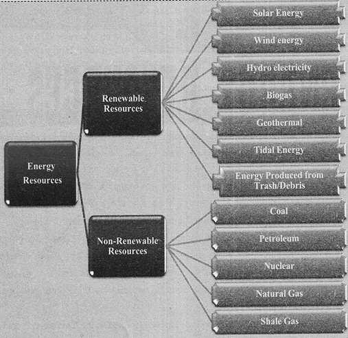
On the basis of generation, energy sources can be classified into two types: Nonrenewable and Renewable. On the basis of the uses the energy sources can be classified as the Commercial energy and Noncommercial energy.   Nonrenewable resources Non-renewable energy is a source of energy that will eventually run out, such as fossil fuels and nuclear material. These resources have been the most used type of energy in the modem era. These are also known as conventional sources of Energy.   Renewable resources Renewable energy is energy produced from sources that do not deplete or can be replenished within a human's life time such as wind, water, solar, and geothermal, come from sources that regenerate as fast as they are consumed and are continuously available. Such as biofuel produced from food crops and other plants, are replenished every growing season. In the early part of the twenty-first century, renewable sources have become more popular as nonrenewable sources have begun to be depleted. These are also known as Non- conventional sources of energy.   Commercial energy  The energy sources that are used to generate electricity and that are available in the marketplace with a specific price are known as Commercial energy sources. The most commercialized forms of energy sources are electricity, coal, advanced petroleum products and nuclear energy etc.     Non-commercial energy   Non-commercial energy sources, which include fuels such as cattle dung and agricultural and urban waste, are conventionally gathered and not bought at a price used particularly in rural areas. These are also called Traditional fuels and are often ignored in energy accounting.   Energy Resources in Madhya Pradesh   
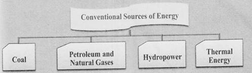
There are various conventional sources of energy in Madhya Pradesh which are coal, oil and mineral oil, natural gas, atomic energy. Non-conventional sources of energy are solar energy, wind energy etc. The two main sources of energy in Madhya Pradesh are coal and Hydel power. The reorganization of state has affected its electricity production drastically.   Conventional Sources of Energy in MP Some important conventional energy sources are discussed below-     1.            Coal  

      CHAPTER-9 INDUSTRIES   The industries of Madhya Pradesh provide a firm basis to the economy of Madhya Pradesh. According to Economic Survey 2018-19, the contribution of industries in the state's GDP is 23.87% in 2016-17. Madhya Pradesh is on 7th place in terms of industrial development. Madhya Pradesh has a strong base of mineral resources and accounts for 14% of India's total cement production. The state has an oil refinery at Bina with an annual capacity of 6 MMT. The installed power capacity of the state is over 23,400 MW; 35% of which is contributed by renewable energy sources. The state is a leading producer of a variety of horticulture crops and offers lucrative opportunities for food processing industries. The state also offers opportunities in textile manufacturing, automobiles, food processing, soya processing, engineering and agriculture equipment manufacturing, among others. According to the Ease of Doing business report published by World Bank and DIPP 2019 MP Stands on 4th Position.    On the basis of the raw material used, the various industries can be categorized as follows:-     Agriclture Based Industries   The agriculture based industries are dependent on the agriculture for their raw material. These industries are the most crucial in the initial phase of development and have highest access among people as they fulfill the basic needs of a common man. In Madhya Pradesh major agriculture based industries are:        Sugar Industry      
    • The first sugar mill in the state was established at Jawra (Ratlam) in 1934, since, sugarcane is cultivated majorly in the Western districts of the state, and major sugar mills are situated in the Western districts of the state.                                     
    • The largest sugar mill of the state is at Bariai in Sehore. Others are Dabra Sugar Mill (Gwalior), Jiwajirao Sugar Co. (Mandsaur), Jawra Sugar Mill (Ratlam), Seth Govind Das Sugar Mill (Ujjain), Sarangpur, Balsai and Aalot Sugar Mill. There are 27 sugar mills If Madhya Pradesh. 
      Locational Factors  
    • Raw Material: Sugarcane is a perishable and weight losing raw material about 90 percent of the material is wasted and only 10 percent sugar is produced. Hence Sugar industries are located near the sugarcane producing areas.                         
    •  Transportation: Location of sugar mills closer to the farmers enables the farmers to bring their produce to the mills easily using transportation like bullock carts, tractors etc.
    •  Availability of labour: Cheap labor should be available at local level.
    •  Availability of Capital- Growth of any Industry depends on low interest loan with supporting policies of Government and same are the case for sugar industry.
    •  Power-Constant supply of electricity in extremely needed for industrial growth.
    • Market availability: Sufficient level of market is available for the consumption of the sugar in the state.
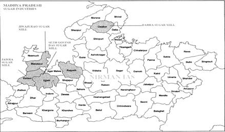
        Problems with sugar industry in Madhya more...

      CHAPTER-10 TRIBES   The term 'Tribe' is derived from the Latin word 'tribes'. Earlier Romans used this term to designates the divisions in society. The tribes in India constitute approximate 9% part of the total population. It represents an element in Indian society which is integrated with the culture mosaic of our civilization. The present popular meaning of 'Tribe' in India refers to a category of people, included in the list of Scheduled Tribes. The term "Scheduled Tribes" First mention in "Government of India Act, 1935", than after it was included in the Constitution of India in 1950. The term Adivasi also applies to indigenous people of this area. Adivasi term firstly used by Amritlal Vithaldas Thakkar, popularly known as Thakkar Bapa.     
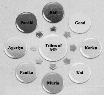
Tribes are relatively isolated from larger cultural influences, have a relative cultural homogeneity and a simple technology. They believe in spirits, magic and witchcraft. They have their own taboos which prohibit certain actions that are punishable by the community, by the supernatural, or by magical consequences.   Characteristics of Tribes
    • Geographical isolation or semi-isolation.
    • Definite Common Topography. 
    • Unacculturated or partially acculturated into national society.
    • Largely or entirely independent of the national economic system.
    • Ethnic distinctiveness from the national society.
    • Economic base tightly dependent on their specific environment.
    • Distinct Political Organization.
    • Rudimentary type of Religion.  
    • Distinct customs, rituals and beliefs.
    • Sense of Unity.
    • Endogamous Group.
    • Common Dialect.
    • Common Culture.
    • Distinct political organizations.
    • Ties bond-Relationship.
      Tribes of Madhya Pradesh  
    • There are 46 recognized Scheduled Tribes in Madhya Pradesh, three of which have been identified as 'Particularly Vulnerable Tribal Groups (PTGs) (formerly known as ?Special Primitive Tribal Groups'). The population of Scheduled Tribes (ST) is 21.1% of the state population (15.31 million out of 72.62 million), according to the 2011 census.
    • Madhya Pradesh occupies 1st place from the Scheduled Tribe population point of view. As per census of 2011 the lowest population of scheduled tribe in the state is 613ti persons in Behind district while maximum population is in Dhar district (12,22814).
    • According to the 2011 Census of India, Bhil is the most populous tribe with a total population of 4,618,068, constituting 37.7 per cent of the total ST population, Gond is the second largest tribe, with a population of 4,357,918 constituting 35.6 per cent. The, next four populous tribes are: Kol, Korku, Sahariya and Baiga. These six tribes constitute 92.2 per cent of the total ST population of the State.
    • Pardhan, Saur and Bharia Bhumia have a population ranging from 105,692 to 152,472 together, they form 3.2 per cent.
    • Four tribes, namely Manjhi, Khairwar, Mawasi and Panika having population in the range of 47,806 to 81,335 account for another 2.2 per cent of the ST population; remaining thirty three tribes (out of total of 46 tribes) along with the generic tribes constitute the residual 2.5 per cent of total ST population.
    • According to census, 2011 more...


    You need to login to perform this action.
    You will be redirected in 3 sec spinner

    Era Rock Group
    Latest Alluvium
    Pleistocene Ancient Alluvium and Laterite